The return cross-country trip was filled with so many adventures, incredible experiences, and spectacular moments that I fear it would take weeks, if not months, to write a blog. So, I'll select just a few highlights and photos as a sample of this wonderful trip home.

My last night in Pacific Grove - an amazing sunset to end an amazing summer.
My route home was certainly not the most direct! I started by heading north up Highway 1 through Santa Cruz then a quick stop to view the lighthouse at Pigeon Point.

At San Gregorio I bid farewell to the ocean and turned inland. This summer I loved re-connecting my spirit to the ocean and know I will greatly miss the sea. I turned east and followed Highway 84 up and over the hills then crossed over the Dumbarton Bridge near the head of San Fransisco Bay. I followed a twisty route still trying to avoid Interstate Freeways climbing up through Niles Canyon Road to reach Livermore.

Beautiful sun burnt brown hills and green oak trees near Livermore.
There was no now avoiding Freeways so I joined Interstate 205 passing through Tracy then at Manteca I made a turn north up Interstate 5 to Stocktown. I soon rejoined my favorite type of road; a narrow, twisting, county highway heading for the mountains. In this case it was Highway 4 passing through the rich agricultural farmlands of the San Joaquin Valley before an interesting stop at Farmington where I meet some wonderful folks who knew my friends Bob and Bill.

The old store at Farmington. Where I meet some wonderful new friends.

My favorite kind of road - heading towards Angles Camp up Highway 4.
Then on into the mineral rich foothills passing Copperopolis (once home to a massive copper mine) before stopping for the night at a cheap motel in the old gold mining town of Angels Camp. This town was the setting for the famous short story written in 1865 by Mark Twain called "The Celebrated Jumping Frog of Calaveras Country" . The sidewalk of the main street has a hall of fame in a style similar to the Hollywood Walk of Fame Stars - only this one is to recognize the champion from the annual frog jumping festival.

Main Street Angels Camp.

Sidewalk "Frog of Fame" marker for the one time world record holder
"Johnny Jumper" 20 feet, 3 inches (since beaten by "Rosie the Ribeter" with 21’ 53/4”).
The next morning I carried on following beautiful Highway 4 gradually climbing as I passed through a series of interesting old mining towns that now seem to survive on tourists: Murphy's, Avery, and Dorrington. I loved driving through the forested Sierra Nevada mountains before finally cresting the range at Ebberts Pass at 8,730 feet above sea level.

Cabin and alpine lake near the summit of Ebberts Pass.
A very steep descent down the eastern side before climbing up and over Monitor Pass at 8,314 feet. I now left California (briefly) and headed into Nevada as I skirted Topaz Lake and drove through Wellington. This Wellington being considerable smaller than capital city of the same name in New Zealand.
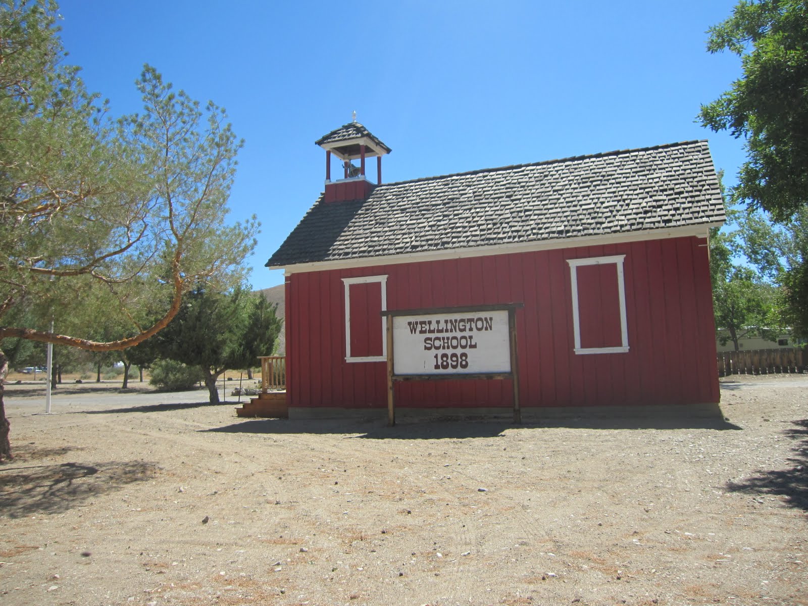
Old one-room school house in Wellington, Nevada.
Back into California and a visit to the Forest Service ranger station in Bridgeport to get directions to a near by hot spring I had read about. This was an amazing place for a soak as there were several hot springs with fabulous views of the Sierra Nevada mountains.


Beautiful hot springs near Bridgeport, CA.
A drive past spectacular Mono Lake before cutting across Highway 120 arriving into the tiny town of Benton Hot Springs right on dusk. For $40 I got a campsite with my own hot mineral pool looking out to the White Mountain Range and Boundary Peak - the highest point of Nevada. To say this was an incredible experience is not adequate description for a night spent soaking in my own private hot tub alternated with reading by moonlight beside my campfire. I was even up early and back into the pool to watch the sunrise.


Sunset from inside my own hot pool. Boundary Peak on the left.
Now my adventure got a little more adventurous than I planned. I was aiming to add Nevada to my list of the 50 US state highpoints climbed - but my vehicle had other ideas. Although, in hindsight I can't complain as my trusty 2000 Ford Windstar van with 140,000 miles on it has taken me some incredible places over the years. I reluctantly left the hot pools of Benton and headed up a rough (in hindsight way too rough) dirt road towards an old mining outpost high on the slopes of Boundary Peak.

The old mining camp with Boundary Peak towering above on the far left.
Having made the van work very hard to get there I was dismayed to discover transmission fluid pouring out of the engine so I beat a hasty retreat to the nearest town of Bishop. There the mechanical diagnosis was not good with reports of a broken transmission seal, a $2,000 estimated repair bill, and a 85% chance of the van getting me back to Minnesota. A stressful decision making process taking several hours as I deliberated options. I settled on still trying to reach Boundary Peak by a much longer eastern approach from near the small town of Dyer.

A lonely highway near Dyer, Nevada.
I drove up the access road as far as I felt comfortable taking the van, pitched my tend beside the pond of an old dam, and set my watch alarm for a very early start.

I was up and away before first light riding my mountain bike up the steep access road that I felt was beyond the van in its damaged state. Riding two miles uphill at 8,500 feet following a rocky, steep, heavily rutted trail with only the narrow beam of my headlamp for illumination was a pretty exciting start to the day. Sunrise arrived quickly with my goal - the summit of Boundary Peak, brilliantly illuminated.

Sunrise arrived as I was mountain biking up the access road to the Boundary Peak trail head.
The summit is the peak in the center.
The road ended at the head of Trail Canyon and the hiking route then began. Although hiking trail is being too kind as this was essentially an exercise in route finding heading up through the thickets of willows, then across the knee-high sage in the center of a broad valley, then picking the path of least resistance up ever steepening rock scree slopes. Finally, after some very sketchy rock climbing moves I reached the ridge at 12,000 feet and then had another long-slog with significant drop-offs on either side to reach the highpoint at 13,140 feet.


Mile after mile of fairly desperate climbing up increasingly steep slopes of rock scree.
Shortly after 1pm I reached the summit - the 46th US state I've highpointed.

On top of Nevada - at 13,140 feet above sea level.
I took a much longer (and safer) route down but developed massive blisters, ran out of food and water, and really suffered from the over 100 degree heat in the valley. The highlight was seeing a herd of wild horses and walking down through a grove of bristlecone pine trees (Pinus longaeva), the oldest living trees in the world. Eventually I reached my bike and had a thrilling decent back down the access road to reach the van arriving some 12 hours after leaving, feeling thrashed, but thrilled at having made the summit and having enjoyed a tough hike in a very remote mountain range.
I drove for an hour to reach the town of Tonopah where a $28 night motel room after an equally cheap meal at a local casino did much to restore me. The next morning it was hot; quickly reaching 104 degrees. The only thing more concerning was the ever-increasingly number of times that the transmission was slipping. I was stopping fairly frequently to pour in transmission fluid as I was leaving a steady stream of it along the sun baked roads. The old town of Goldfield providing an interesting stop for me to stretch my legs and the van transmission to cool. While 440 people still live here the "ghost city" is a shadow of its former glory when it was home to over 30,000 citizens. Most of the old buildings remain, some well preserved by the dry desert climate and others by people who share my belief that these old treasures are worth saving.


Back on the road to pass the Nevada Test Range - once the site of nuclear explosions and still heavily military including the (in)famous Area 51. As I approached Las Vegas I was forced to accept the inevitable - the van was dying and would not get me home. After much appreciated advice from Terry and then Jane the decision was made - I would be buying a car in Vegas. Rolling into North Las Vegas I found the first street with numerous car dealers and then proceeded to look and test drive several. It soon became clear that there was not much difference in price between a "better" used car and a new model. So, after just 5 hours I signed the final paper work to trade in what remained of the van and collected the keys to my new 2010 Toyota Rav4. I unloaded the contents of the well-packed van, now looking somewhat forlorn with a spreading pool of transmission fluid, loaded up the Toyota, and headed to a nearby casino hotel for much needed sleep.

"Thanks - you served me well" - my last look at my trusty old Ford Windstar van.

"Let the adventures begin" - my new Toyota Rav4.
I left Las Vegas late on Saturday morning after a wonderful sleep and an insanely huge breakfast thanks to an all-you-can-eat buffet in the casino. I headed to Boulder City and then into Boulder Canyon, and over Boulder Dam. Although the dam is now known as the Hoover Dam. Given the fact it was now a toastie 114 F degree (46 Celsius) I decided to stop for a tour and to enjoy the air-conditioned museum.

Temperature in the shade at the Hoover Dam.

Hoover Dam.
Everything about this structure is impressive. The tour started with an interesting movie, was followed by a long elevator ride to the base of the dam to view the powerhouse, and concluded with a hike along the sidewalk across the crest. Inside were surprises including beautiful art deco inspired designs and art work. Yet, it is the sheer scale of the dam which leaves the strongest impression. To learn more about the Hoover Dam, click here.

View from the crest of Hoover Dam to the powerhouse below, the Colorado River, and the soon-to-be-completed $114 million Mike O'Callaghan - Pat Tillman Memorial Bridge.

The turbines of one of the two generating stations at the base of Hoover Dam.

The water intakes for the power station with a greatly reduced Lake Mead behind.
I drove across the dam and at the mid-point passed out of Nevada and into Arizona. I'll carry on with that chapter of the story home in the next blog post.