
Farm fields near Gilroy.
Onwards now heading east following California Highway 152, passing the large Sisk Dam and San Luis Reservoir. This is a fairly interesting place as it is the largest off-stream reservoir in the US. A massive earth dam, 300 feet tall and over 3.5 miles long holds an enormous amount of water, yet it receives barely any of it from one very small stream. It gets the vast majority of its water from the Sacramento River Delta where to prevent the water being "wasted" by flowing into the ocean it is captured and then pumped hundreds of miles up-hill and inland to the San Luis Reservoir where it can be stored until being sent via the massive California Aqueduct to various cities and agricultural irrigation projects.
We carried on before stopping for lunch at a roadside takeout restaurant in the amusing named Los Banos (Spanish word for bathrooms or toilets).

On east following Highway 152 until it intersected with California Highway 99 which we followed south to Frenso which looked every bit as large as the reported 1 million metro population (making it the 5th largest city in the state). Here we swung east once more now following the very scenic California Highway 180 which we would eventually travel to its terminal deep inside Kings Canyon.

We followed the steeply climbing highway, entered into Kings Canyon National Park, and immediately paid a visit to the Visitors Center. After a fairly quick look at the somewhat tired and dated displays we resumed our driving following the Scenic Byway road that heads deep into the park.

Heading into the South Fork of the Kings River - note the road far below.


The road into the heart of Kings Canyon - an impressive feat of engineering.
Finally we reached the South Fork of the Kings River which was very much in flood with the spring melt of snow from the highlands.

The raging South Fork of the Kings River - note the trees in the flooded steam bed.
The flooded river was threatening to force a closure of the road - something we were warned about at the visitors center. There is something frightening above a river in flood and standing on its banks you cannot help be impressed but by the enormous power. But also fully aware of the awesome destructive force. Several people are killed each year in this national park by the snow melt flooded rivers.

At the end of the road sheer granite cliffs rose up on both sides of the valley.

We did a short walk to Muir Rock – so named because environmentalist, John Muir used to deliver impassioned speeches about the need to protect the Sierra Mountain Range from this rock beside the river. The approach must have worked - because in 1890 the first portion of the current park was established to protect the giant sequoia trees, making this America's second oldest national park.

We drove back to the Visitor Center enjoying the amazing colors of the late afternoon sunlight on the canyon walls and passing large patches of snow still lingering beneath the trees. It was clear to see that the river was still rising.


Lone Pine tree growing on cliff ledge.

We now made our way to the Grant Grove. This section of Kings Canyon National Park was established to protect a grove giant sequoia trees. It includes the General Grant tree, the second largest tree in the world. Grant Grove covers a little over 154 acres.

This tree was named in 1867 after Ulysses S. Grant, Union Army general during the Civil War and the 18th President of the United States (1869-1877). President Calvin Coolidge proclaimed it the "Nation's Christmas Tree" on April 28, 1926. On March 29, 1956, President Dwight D. Eisenhower declared the tree a "National Shrine", a memorial to those who died in war. It is the only living object to be so declared. The tree is the second largest tree in the world after the General Sherman tree as of 2005, when the Washington tree, which was previously in second place, lost half its trunk. Once thought to be well over 2,000 years old, recent estimates point to a much younger age closer to 1,650 years.

The General Grant Tree was an absolutely impressive sight to see. The eastern side has a huge burn scar from an ancient lightning strike. The diameter at ground level is a staggering 40.3 feet (12.3 m) making it the largest diameter tree known in the world. It would take 20 people holding out stretched hands to make a complete circle around the base. The Grant Tree has a volume of 46,608 cubic feet (1,320 cubic meters).
The walk through this grove of massive tress is incredible. There are many other named trees in this grove including several named after US States. The California Tree had an impressive diameter of 22 feet whereas, Minnesota was somewhat smaller at 10 feet. But still, a tree with a diameter (meaninng if you cut it down the distance across the widest part of the stump) of 10 feet is still very large.

In the Grant Grove.
After an over-priced but tasty dinner at the restaurant beside the visitors center we used the car headlights to pitch the tent in the dark and enjoyed a relaxing night’s sleep beneath the forest giants.

Our wonderful campsite beneath the towering trees. The brown metal box is to keep all food inside over night to keep the bears from breaking into tents and cars.

Poster warning of what happens when you do not use the bear box to store food.
Sequoiadendron giganteum (Giant Sequoia) is the sole living species in the genus Sequoiadendron, and one of three species of coniferous trees known as redwoods. Giant Sequoias are the world's largest trees in terms of total volume. They grow to an average height of 50–85 m (165–280 ft) and 6–8 m (18–24 ft) in diameter. Record trees have been measured to be 94.8 m (311 ft) in height and 17 m (57 ft) in diameter. The oldest known Giant Sequoia based on ring count is 3,500 years old. Sequoia bark is thick and protects the tree – it can be almost a meter (3 feet) thick. The natural distribution of giant sequoia is restricted to a limited area of the western Sierra Nevada mountains in California. It occurs in scattered groves, with a total of 68 groves recorded. Nowhere does it grow in pure stands with a mixture of other pine and conifer species. Groves range in size from 1,240 ha (3,100 acres) with 20,000 mature trees, to small groves with only six living trees. Giant sequoia is usually found in a humid climate characterized by dry summers and snowy winters. The elevation of the giant sequoia groves generally ranges from 1,400-2,150 m (4,600-7,000 ft). The wood from mature giant sequoias is highly resistant to decay, but is fibrous and brittle, making it generally unsuitable for construction. From the 1880s through the 1920s logging took place in many groves in spite of marginal commercial returns. Due to their weight and brittleness trees would often shatter when they hit the ground, wasting much of the wood. Loggers attempted to cushion the impact by digging trenches and filling them with branches. Still, it is estimated that as little as 50 percent of the timber made it from groves to the mill. The wood was used mainly for shingles and fence posts, or even for matchsticks. Pictures of the once majestic trees lying logged, broken, and abandoned in formerly pristine groves, added with knowledge that the wood would be put to such modest use, spurred the public outcry that caused most of the groves to be preserved as protected land.

Looking into the Redwood Mountain Grove - the worlds largest grove of the worlds largest tree. Over five square miles containing over 2,100 sequoia with a diameter of 10 feet or greater.
We carried on driving through the forest on twisting narrow roads to visit Hume Lake.


This may look the very definition of the best of nature - but in fact the lake is man-made. It was created to have a reservoir to float logs down a 62 mile flume, the worlds longest. Believe it or not, adventurous people would even ride the flume in specially designed boats. When the logging operations ceased the property was bought by a christian camp which runs all sorts of programs from this incrediblly beautiful spot.
Onwards further into the park where we found snow lingering at the higher elevations and the distant peaks still covered in snow. Not surprising given that many years a 40 foot snow pack blankets the upper reaches of the Sierra Nevada Mountains.
Onwards further into the park where we found snow lingering at the higher elevations and the distant peaks still covered in snow. Not surprising given that many years a 40 foot snow pack blankets the upper reaches of the Sierra Nevada Mountains.


We now headed to the Giant Grove which is home to the worlds largest tree.
The General Sherman with a height of 275 feet (83.8 metres), and volume of its trunk of 1,487 cubic meters, is the world’s largest tree (and the largest living thing on the planet). The tree is believed to be between 2,300 and 2,700 years old. In 1879, it was named after American Civil War general, William Tecumseh Sherman, by naturalist James Wolverton, who had served as a lieutenant in the 9th Indiana Cavalry under Sherman. In 1931, following comparisons with the nearby General Grant tree, General Sherman was identified as the largest tree in the world. One upshot of this process was that wood-volume was widely accepted as the defining factor in establishing the world's largest tree.

The General Sherman Tree. Click on the photo above, then look really close on the right hand side and you will see people to give a sense of the size of this massive tree.
As many of my New Zealand family and friends are reading this I tought I would provide a point of contrast with the General Grant Tree to Tāne Mahuta, the giant Kauri which is the largest tree in New Zealand.
Battle of the Big Trees: USA versus New Zealand
Battle of the Big Trees: USA versus New Zealand
General Grant Tree – Giant Sequoia versus Tāne Mahuta – Giant Kauri
Height: 275 feet (84 meters) versus 168 feet (51 meters)
Circumference of trunk: 103 feet (31.3 meters) versus 45.2 feet (13.7 meters
Age (estimated): 2,300- 2,700 years versus 1,250, 2,500
Estimated volume : 52,508 cubic feet (1,486.6 cubic meters) versus 18,247 cubic feet (516.7 cubic meters)
So, put another way, almost three Tāne Mahuta kauri trees would fit inside the General Grant.

The trunk of the General Sherman (people of left for scale).

I needed to back up a long way to get the whole tree in a single photo. If you have really good eyes you can see people around the base - they look like ants.

Trail on the way out from the Giant Grove passes through the log of a fallen sequoia.
It was now quite a warm day so we took the cheaters approach rather than walking the mile back uphill to the car we caught a convenient free shuttle bus back to the car park.

Back on the road I caught something out the corner of my eye and pulled over for a closer look. It proved to be a black bear and her cub feeding on the spring grasses. This is the closest I've been to a bear in all my years in the US. A fabulous experience to watch this powerful animal and her super cute little cub mostly hidden behind the trees.

The next stopping place was Moro Rock - a huge granite dome standing on the southern rim of the Giant Forest plateau. It somewhat resembles Half Dome in Yosemite National Park, except that this is a whole dome. Common in the Sierra Nevada, these domes form by exfoliation, the casting off rock layers on otherwise smooth unjointed granite. This occurs as a result of the slow expansion of the granite rock and ultimately results in rounded dome-like forms.
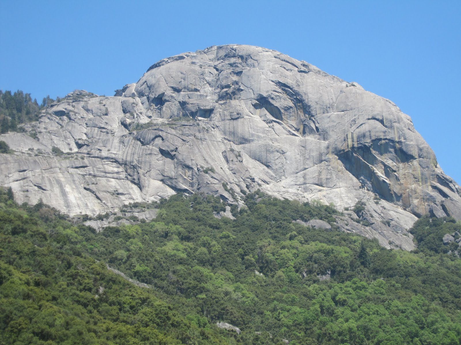
The summit elevation of Moro Rock is 6,715 feet. The eastern, southern, and western faces of the rock are precipitous cliffs over a thousand feet in height that attract the world’s top rock climbers. The northern side of the rock is connected to the Giant Forest plateau by a granite ridge. The Moro Rock Stairway has 400 steps that follow this ridge and lead to the summit of the peak.

Setting off to climb Moro Rock.
The 797-foot-long stair was designed by National Park Service landscape architect Merel Sager and engineer Frank Diehl, and was built in 1931, following natural ledges and crevices using labor from the Civilian Conservation Corps. It replaced a wooden stairway built in the 1920s that had deteriorated dangerously. Unlike the earlier stairway, the new stairway adopted a design policy of blending with the natural surfaces to the greatest extent possible. For this reason it was added to the National Register of Historic Places.


Use of this trail is discouraged during thunderstorms as several deaths have occurred from lightening strikes.
The views from the top were simply stunning - made more so by the day without a single cloud in the sky.

The view from the top of Moro Rock also provided a preview of the road we would traverse as we dropped off the plateau down to the follhills and into the Kaweah River Valley.

The view from Moro Rock looking at the road down to the Kaweah Valley.
We ended our traverse of the National Parks by making a visit to the FootHills Visitor Center located next to the Park Headquarters. It was a long, hot, dry journey home but it still provided several interesting sites to see. Firstly, the citrus groves surrounding the very aptly name town of Lemon Cove, the flooded Lake Kaweah with water up to the roof of picnic shelters and bathroom blocks. Then on through Visalia, Hanford, then Lemoore which is home to a massive US Navy Air Station. We ate dinner at a 1950s themed diner in Coalinga that I'm not sure was decorated, but rather showing the last time any updating on the propety was done. Up and over the very scenic California Highway 198 into Priest Valley which had it grass covered hills bathed golden in the evening light. Out to meet US 101 at San Lucas and then another hour and we were home.

Evening light on the hills near Priest Valley.


