Wednesday, May 26, 2010

Summer 2010 Westward Journey Part IV: Through the Rockies.

I awoke on the forth morning of my cross country odyssey excited for what lay ahead today. I felt a little daft when packing my vehicle in Minnesota on a hot and humid early summer day for the drive to the California Coast when putting in my skis and warm winter clothing. But, I had looked online and saw that there was still skiing to be had in Colorado. Today was going to be a ski day. After a quick breakfast in Idaho Springs I drove about 30 minutes following I70 which parallels Clear Creek passing through a series of old mining towns including Dumont, Georgetown, and Silver Plume. 

Old mining relics beside I 70 in Colorado.
Just before the Interstate dives into the Eisenhower Tunnel (which by the way is the highest point on the nations Interstate highway system at 11,158 feet or 3,401 meters above sea level) I turned off onto US Highway 6 for the climb up and over Loveland Pass.
 
Interstate 70 as it enters into the Eisenhower Tunnel beneath Loveland Ski area.
Loveland Pass, elevation 11,990 ft (3,650 m) above sea level, is a high mountain pass in the Rocky Mountains of northern Colorado. The pass is named for William A. H. Loveland, a resident of Golden during the late 19th century who was president of the Colorado Central Railroad. It is located on the Continental Divide in the Front Range 60 miles west of Denver. U.S. Highway 6 traverses the pass; the twisty road is considered to be especially treacherous during the winter months. A steep, steady 6.7% grade, along with numerous hairpin turns on either side, make it difficult to snowplow the road regularly. Loveland is the highest mountain pass in the world that regularly stays open during a snowy winter season. When the Eisenhower Tunnel opened in March 1973, it allowed motorists on Interstate 70 to avoid crossing the pass directly. Trucks that cannot pass through the tunnel (those carrying hazardous materials and those over 13.92' (4.24 m) in height) must still take US 6 across Loveland Pass, climbing 800 vertical feet (244 m) above the tunnel.

 
Atop Loveland Pass.
  
Sign for backcountry skiers at the summit of Loveland Pass.
 
I stopped briefly to admire the view and take a photo of the slopes I would soon be enjoying.
Arapahoe Basin from the top of Loveland Pass. 

Arapahoe Basin (but more often referred to as A-Basin or simply, the Basin) is a fairly well-known ski area high in White River National Forest of the Colorado Rocky Mountains. Despite being surrounded by some of the largest and most famous ski areas in the world Arapahoe Basin has a reputation as a smaller Colorado ski area catering for a clientele of hardcore, yet relaxed folks that like simply to ski and avoid the glamour associated with resorts like Aspen and Vail. It is also equally known for its especially long season - staying open until at least June and occasionally early July whereas most other American ski areas close in early May.
My first run of the day heading up the chairlift – 
note the lack of people.
I've found the following interesting article about the couple who started A-Basin. Max and Edna Dercum started Arapahoe Basin as a small family ski area along with the Ski Tip Lodge in the 1940s. This couple have a pretty interesting history themselves. Edna was born Edna Strand on Aug. 2, 1914 in Clarissa, Minnesota to Norwegian immigrant parents and went to high school in Minneapolis. When her father passed away, she finished her education in Pennsylvania, living with a sister. Later as a student at Penn State University, she became the first woman to join forestry professor Max Dercum's fledgling ski club. As she took up his love of skiing, a romance blossomed between the two, and they married in 1937. She became an accomplished ski racer taking the state downhill and slalom titles in 1941. Her husband's dream of developing a ski mountain in the West brought them to Colorado, and in 1942, they moved to Dillon in Summit County. A couple of years later they bought an 80-acre property for $3,000 that included the Ski Tip Lodge. Max joined a group of five partners to develop Arapahoe Basin, which opened in November of 1946 during the post-war ski boom. (A lift ticket then cost $1.25.) Edna worked as a certified ski instructor for 18 years then worked alongside her husband in the late 1960s when he designed and developed Keystone Ski Resort, which opened in November of 1970. She was still skiing competitively winning the world seniors giant slalom championship at age 65 competing all over North America and Europe, winning medals in Italy and Switzerland. She continued skiing well into her 80s. She passed away in September 2008 at age 94.


The following information comes from the A-Basin website and Wikipedia. Since its opening in 1946 Arapahoe Basin has continually expanded to now include 105 trails over 900 acres served by 7 lifts. The base of the ski area is at 10,780 ft (3,290 m) with a vertical rise of 2,270 ft (6,90 m) with a summit elevation of 13,050 feet (3,977m) [for family and friends reading in New Zealand – this is 734 feet/224 meters higher than our tallest mountain; Aoraki/Mt. Cook]. It is widely regarded as the highest ski-able terrain in North America (although the Telluride resort boasts Palmyra Peak (13,320ft) and Silverton Mountain has terrain up to 13,487 feet). Due to its high altitude (at tree line) and its mostly north to northeast face, A-Basin remains open for skiing much longer than most ski resorts, and often starts earlier as well. In recent years the season has extended from very early October through to early July. Though it is mostly known for advanced and expert terrain, A-Basin also has runs for the novice and intermediate skier. The Pallavicini lift services mostly black and double black terrain on the west side of the mountain. The Pallavicini face itself contains a group of very steep and seemingly endless mogul runs with ratings double black diamond extreme.
The Pallavicini lift and face at A-Basin.
[Note: When I skied here a number of years ago I skied the Pallavivini face and recall it being among the steepest, most demanding, and extreme skiing I've ever done. Let's just say that day at A-Basin a few years back was the first day I have skied with a helmet – a decision I've never regretted. I didn't know where the name Pallavicini came from until I climbed the highest mountain in Austria last year – Grossglockner. On that mountain is a famous (some may say infamous ice gully) that is ridiculous steep. It was first climbed by Alfred Pallavicini in 1876 (although it killed him and the rest of his party as you can read about here). I remember my guide on the summit of Grossglockner pointing out the Pallavicini Route as we climbed by on a much easier route and thinking "Oh – that is where the name at A-Basin comes from"].

From the top of the A-Basin with great views of Lake Dillon 
and the ski areas of Breckenridge and Keystone.
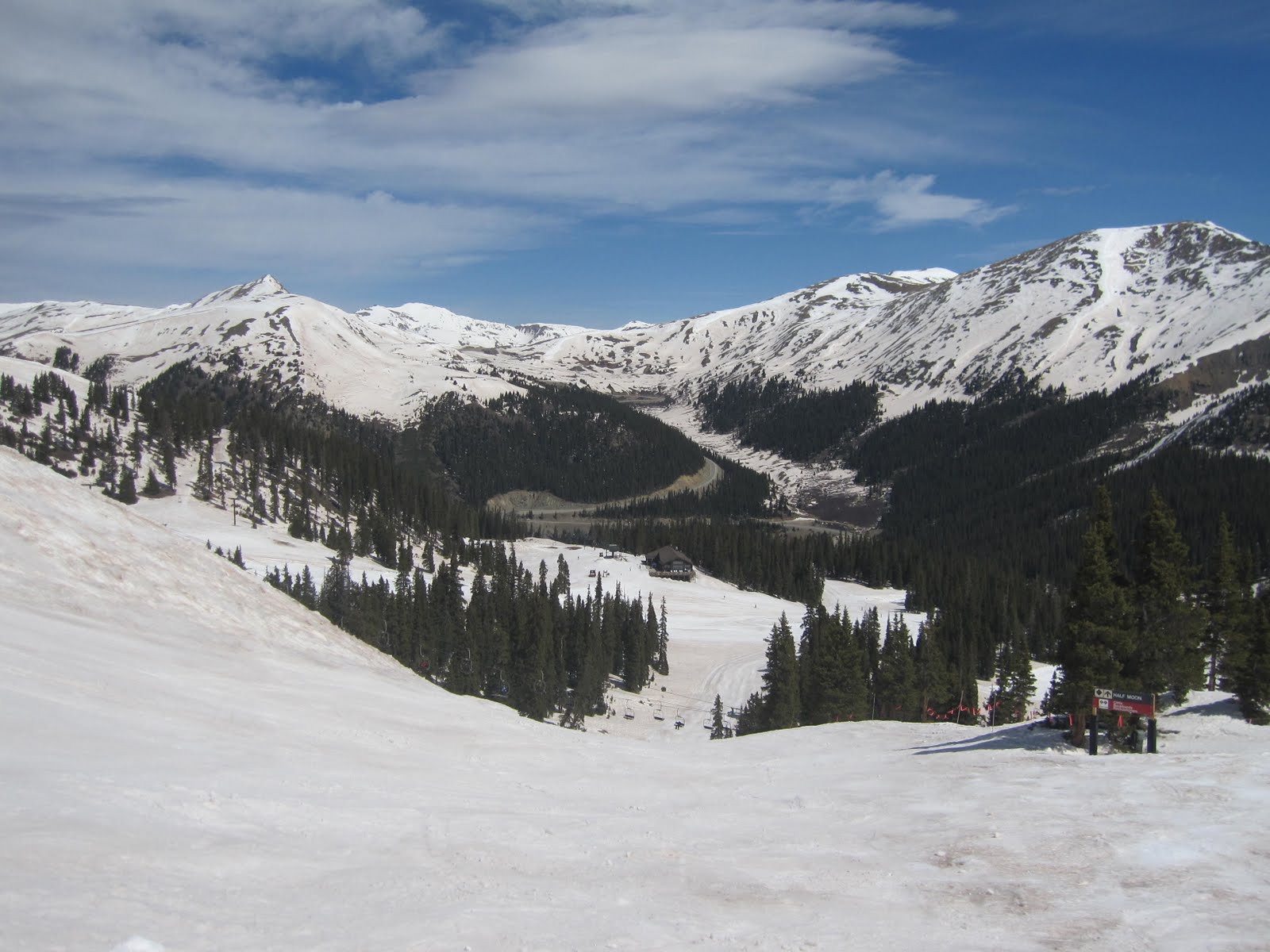
On the slopes of A-Basin looking back at Loveland Pass.
 
It was a warm spring day with only two of the lifts operating but it still gave access to vast acres of terrain. There were very few other skiers and snow boarders with no lift lines at all. It was surprisingly hot (shorts and t-shirt weather) at the base of the mountain but below freezing with a stiff wind blowing by the time you reached the top. Spring skiing means heavy snow which is tiring. Despite an inch of fresh snow within the previous 48 hours by mid afternoon it was quite slushy and my legs were pretty wiped out. I decided to call it a day before tiredness caused an accident. But what a fabulous day of skiing. I am so grateful that my parents introduced me to this sport as a kid in New Zealand. I look back now and absolutely treasure the days skiing at the little ski area of Porters Heights with Mum, Dad, and my sister Rose. I will also treasure my day at A-Basin during my cross-country journey.
Lunchtime chillin' at A- Basin – May 2010.

I rejoined Interstate 70 at Dillion and then passed a series of ski areas: Copper Mountain, Vail, and Beaver Creek. All were closed for the season with just small remnant patches of snow visible.
Not much snow left at Cooper Mountain (which 
had closed for the season).

Up a fairly steep 7% grade to reach the summit of Vail Pass at 10,662 feet (3,249 m) before dropping down into the drainage of the Eagle River in flood with the spring melt. I passed the massive gypsum mine that gave the city of Gypsum its name. Beside the freeway is a large processing facility where the gypsum is turned into drywall (also called sheetrock or GIB Board).  Then the terrain changed greatly as I carried on west through Glenwood Canyon. 

 Entering Glenwood Canyon.

This rugged and beautifully scenic 12.5 mile (20 km) canyon was carved by the Colorado River in western Colorado. The canyon walls climb as high as 1,300ft (396m) above the river making it the largest canyon on the upper reaches of the Colorado River. The canyon was formed relatively recently in Pleistocene era by the rapid cutting of the Colorado down through layers of sedimentary rock. The canyon stretches from near the town of Dotsero, where the Colorado receives the Eagle River, downstream to just east of Glenwood Springs, on the mouth of the Roaring Fork River.
In the Canyon – railway on the left, two lanes of I 70 
on the right, and the mighty Colorado River in the middle.
   
The canyon is widely considered one of the most scenic natural features on the Interstate Highway System of the United States. Glenwood Canyon has served as the primary transportation artery through the Rocky Mountains, even before the creation of U.S. highways. Railroads have used the canyon since 1887 and a dirt road was built through the canyon in 1906.  Known as the Taylor State Road, this gravel road through the Glenwood Canyon was the first route for automobiles through the Colorado Rockies. The first paved road was built from 1936 to 1938 at a cost of $1.5 million (equivalent to $23 million today). With the Eisenhower Tunnel finished, the last remaining obstacle for I-70 to be an interstate commercial artery was the two lane, non-freeway portion in Glenwood Canyon. Construction had started on this section in the 1960s with a small section opening to traffic in 1966.  The remainder was stopped due to environmentalist protests that caused a 30-year controversy. The original design was criticized as "the epitome of environmental insensitivity". Engineers scrapped the original plans and started work on a new design that would minimize additional environmental impacts.  A new design was underway by 1971 which was approved in 1975; however, environmental groups filed lawsuits to stop construction, and the controversy continued even when construction finally resumed in 1981.  The final design included 40 bridges and viaducts, three additional tunnel bores (two were completed before construction was stopped in the 1960s) and 15 miles (24 km) of retaining walls for a stretch of freeway 12 miles (19 km) long.  The project was further complicated by the need to build the four lane freeway without disturbing the operations of the railroad. This required using special and coordinated blasting techniques.  Engineers designed two separate tracks for the highway, one elevated above the other, to minimize the footprint in the canyon. The final design was praised for its environmental sensitivity.   A Denver architect who helped design the freeway proclaimed, "Most of the people in western Colorado see it as having preserved the canyon." He further stated, "I think pieces of the highway elevate to the standard of public art."  The freeway was finally completed on October 14, 1992 in a ceremony covered by media nationwide. Most coverage celebrated the engineering achievement or noted this was the last major piece of the Interstate Highway System to open to traffic. The cost was $490 million (equivalent to $800 million today) to build 12 miles (19 km), 40 times the average cost per mile predicted by the planners and thus making it the most expensive non-urban freeway in the United States.

It was an incredible stretch of road – not quite sure I agree with the public art comment, but then again it does seem quite fitting. At the west end of the canyon you immediately enter into the town of Glenwood Springs.

The town has a long, interesting history. It was originally known as Defiance, Colorado having been established in 1883, as a collection of tents, saloons, and brothels followed over the coming months with an increasing amount of cabins and lodging establishments. It was populated with the expected crowd of gamblers, gunslingers, and prostitutes. Town founder Isaac Cooper's wife Sarah was having a hard time adjusting to the frontier life and in an attempt to make her environment somewhat more comfortable, persuaded the founders to change the name to Glenwood Springs, Colorado after her beloved hometown of Glenwood, Iowa. Its unique location at the confluence of the Colorado River and the Roaring Fork River as well gaining a stop on the railroad made it a center of commerce in the area. In the late 1800s and into the early 1900s it gained a reputation as a fashionable vacation retreat largely driven by the building of the Colorado Hotel.

The Colorado Hotel in Glenwood Springs.

This hotel was established by silver magnate and banker Walter Devereux. Construction began in 1891 at a cost of $350,000. Edward Lippincott Tilton designed the building as a replica of the Villa de Medici in Rome, Italy. Local materials used include cream-colored Roman brick and Peach Blow Sandstone; imported items included 12,000 yards of carpet and 2,000 rose bushes. The Hotel Colorado opened on June 10, 1893 to a program including a fireworks display, and a full orchestra playing in the ballroom.  The hotel quickly became a popular summer retreat, earning the nickname of "the little White House of the West" after extended visits by Presidents Theodore Roosevelt and William Howard Taft. The teddy bear is alleged to have been invented during President Roosevelt's 1905 visit to the Colorado Hotel. To cheer President Roosevelt after an unsuccessful day of hunting, Hotel Colorado maids presented him with a stuffed bear pieced together with scraps of fine material. Later, his daughter Alyce admired it saying, "I will call it Teddy." The term caught on and became the name for one of the world's most popular toys, the Teddy Bear.
 
I wish I could have afforded the time and money to stay a night at the Colorado Hotel. But, I was drawn to stop at the this town for the same reason that thousands (if not hundreds of thousands) of tourists stop each year – for a soak in the world's largest natural hot pool.

The Glenwood Hot Springs Pool is the largest natural hot springs pool in the world. It is massive at 405 feet long x 100 feet wide making it more than two city blocks long. It contains 1,071,000 gallons of water. A smaller therapy pool is tiny by comparison at 100 feet long x 40 feet wide with only 91,000 gallons. The big pool has water at about 90° F / 32° C whereas, the small therapy pool is kept at a temperature of about 104° F / 40° C. Both pools are directly connect to the Yampah spring located at the eastern end of the property. The spring has a daily flow of 3,500,000 gallons of water, at approximately 122° F/ 51° C.

Thousands of years in the making, the Ute Indians were the first known visitors to the mineral-rich hot springs that flow along the banks of the Colorado River in Glenwood Canyon. They called them "Yampah" meaning "big medicine." In search of these waters with great healing power, Captain Richard Sopris and his party of geographic explorers found the sacred healing spot in 1860. Twenty years later, Walter Horace, James Devereux, and a group of British investors purchased the Yampah Hot Springs along with l0 acres of surrounding land. They set out to harness the 3.5 million gallons of naturally hot mineral water that rises from the source of the spring each day. In 1888 the world's largest hot springs pool was born in the newly established town of Glenwood Springs. It became world-renowned as a healing wonder set in a mountain paradise. Around the turn of the century, the Golden Age of Mineral Spas, it was affectionately known as "Spa of the Rockies", when spa was defined as hot spring bathing. The original red sandstone bathhouse and lodge was built for $100,000 in l890. Designed by Austrian architect Theodore von Rosenberg, the walls of both the pool and the bathhouse were of solid masonry with peach-blow sandstone quarried nearby. The bathhouse featured tubs, Roman vapor baths, special accommodations for pool bathing, a ladies parlor, physician's office, gymnasium, and smoking and reading rooms. Each of the building's 44 bathing rooms included a dressing room and lounge. As word of this new resort spread, aristocrats, political leaders, movie stars, and spiritual believers ventured to Glenwood Springs from around the world. During World War II from 1943 to 1946 the resort, then consisting of the Hotel Colorado and Hot Springs Bathhouse, were used exclusively as a U.S. Naval Convalescent Hospital - the only time in history when it was closed to the public. After the war it was converted into Glenwood Clinic, a private hospital until 1950, and is today known as Glenwood Hot Springs. A new master plan was implemented in l970, including an updated water filtration system, children's wading pool, water slide, and miniature golf. And in l986, a new l07-room Hot Springs Lodge was built just north of the pool. Today the original sandstone lodge is home to the new Spa of the Rockies - a tribute to the resort's magical appeal at the turn of the century.

It was a truly a unique Rocky Mountain swim, perfect after a hard day of skiing. I felt pretty wiped out after a long hot swim, so perhaps where I was headed next will surprise you. Just 10 minutes outside Glenwood Springs is another hot spring, this one could not be more different.

South Canyon Hotspring. 

South Canyon Springs is an amazing contrast to the commercial hot springs in Glenwood Springs. South Canyon consists of a two muddy pools located up on a hillside with great views of the surrounding mountains, including a direct view of Storm King Mountain where 14 wild land firefighters were killed in a 1994 blaze (you can read a US Forest Service report about this tragedy here).

View from inside the pool – looking up 
towards Storm King Mountain.  

The water just bubbles up from the ground (estimated at 112 degrees in a guide book I have that alerted me to this gem of hot spring). The guidebook warned that the conditions of the springs are known to vary – sometimes they are perfect and clear and other times shallow and muddy. For my visit larger pool was relatively clean and hot but the smaller pool was shallow, gross, and filled with a green scum. Needless to say I focused on the larger of the pools.  There were two other locals there and we sat in the hot water talking about other remote hot springs we have enjoyed. 

The source of the South Canyon Hot Springs.

I now pushed on still following Interstate 70 through three amusing named towns (Silt, Rifle, and Parachute). I stopped for dinner in this last town, wondering how a place in the dry western valleys of Colorado would be named Parachute. Here is what I discovered.   The name comes from the appearance on a map of several streams converging on the town. When combined with the arc of the ridge line above the streams it resembles the canopy of a parachute. Parachute Creek was named when the original surveyors mapped the area. In 1908, the name of the town was changed to Grand Valley to lure travelers on their way to the Grand Valley, which is the Colorado River valley to the southwest known for its fruit production. After the local history "Lest We Forget" was published in the late 1970s the town voted in the 1980s to return the name Parachute to the town.  Just south of the town I passed a massive industrial plant which I erroneously thought was oil/or gas related. It turned out to be a recently mothballed chemical plant that processed nearby mined soda ash into sodium bicarbonate (i.e., baking soda).

On westwards following the Colorado River into and then out of Grand Junction. I made a big error by not stopping for the night here as I looked at the map and seeing small towns along my route I decided to push on for just a few more miles towards California. But all too quickly I realized that after a day of skiing, two swims in very hot mineral water, and many miles of driving I was getting very tired. I pushed on expecting to see signs for accommodation – but nothing. Then across the border into Utah and still nothing. 

I bought gas at a little place called Thompson Springs. The guy at the gas station told me my options for a motel were to turn around and drive the 80 miles back to Grand Junction, or carry on for another 20 miles  towards Green Valley (although this had few options for motels/hotels) or drive 30 miles south on US 191 to Moab which he said has lots of accommodation options. Based solely on his recommendation I chose the latter option. He was right, (sort of) as I was presented with a sea of well-lit motel and hotel signs as I approached Moab which made my weary sprits soar. But, one by one I checked each motel and hotel only to be told they had no vacancies. I asked one very friendly chap if he might know of any place in town that  might have a vacancy. I stood by nervously as he made several telephone calls to his hospitality colleagues. I heard him say "One – great, yes just one person for one night". I was so relieved to think I would soon be able to fall on a soft bed and finally get some sleep. Then he told me it was the only room in town and it was the suite at a hotel and it could be mine for just $159, plus tax. Well, that was just too expensive.
 
So despondently I headed on south out of Moab hoping the next town would provide better luck. But after just a few miles I was over-come with tiredness. I saw a roadside rest area filled with RVs and huge trucks and decided the safest thing to do was to pull over. I was going to sleep in the van but I had it fairly well packed, all the RVs and trucks had their generators running producing a most irritating orchestrated din, and finally the rest area was lit with flood lights so bright I'm sure you would be able to pick out this remote spot in Utah from the surface of the moon. My tent and sleeping bag were already in California so I resigned myself to sleeping on my air mattress with my bivy bag beside a picnic table. It now being just after 11:00pm, I was asleep in no time.
 Bed for the night.

At exactly 2:15 in the morning I suddenly felt water failing on me. In my exhausted state I just assumed it was raining. However, I was under the picnic shelter. The "rain" was driving in on me with some of the biggest raindrops I've ever seen outside of the tropics. Then it would seem to stop and move off only to return some 30 seconds later. It wasn't quite adding up as my half-sleeping brain.  I struggled to connect why in the middle of desert, on a bright moonlit night while lying under a roofed picnic area I was getting drenched in the rain. Yes, that's right – I had lain down in a place where the automatic sprinklers could reach me. Once re-situated to the other side of the picnic area it was back to sleep – be it a little wetter than I planned.
Morning showing my accommodations in the rest area 
south of Moab, 
complete with unwanted midnight shower.

Tuesday, May 25, 2010

Summer 2010 Westward Journey Part III: Through Nebraska, Wyoming, and into Colorado


Chadron was a pleasant place to spend the night. The next morning, after a great breakfast with the local farmers at a main street cafĂ©, I continued heading west out of town following US Highway 20. The scenery and the day were both fantastic. Incredible green fields stretching across the plains to abut clay buttes with their flanks covered in pine forests rising abruptly from the farmland.  

Amazing country near Chadron, Nebraska.


About 30 minutes from Chadron I pulled over to view a roadside historical marker. One of the things I love about traveling off the Interstate Freeways and along the slower highways are the historical markers that dot the country side. Usually with signed notification a mile in advance you discover a historical, geologic, or cultural story related to the place, or nearby location. I always try to stop and read roadside markers as it adds so much towards a greater understanding and appreciation of the countryside.

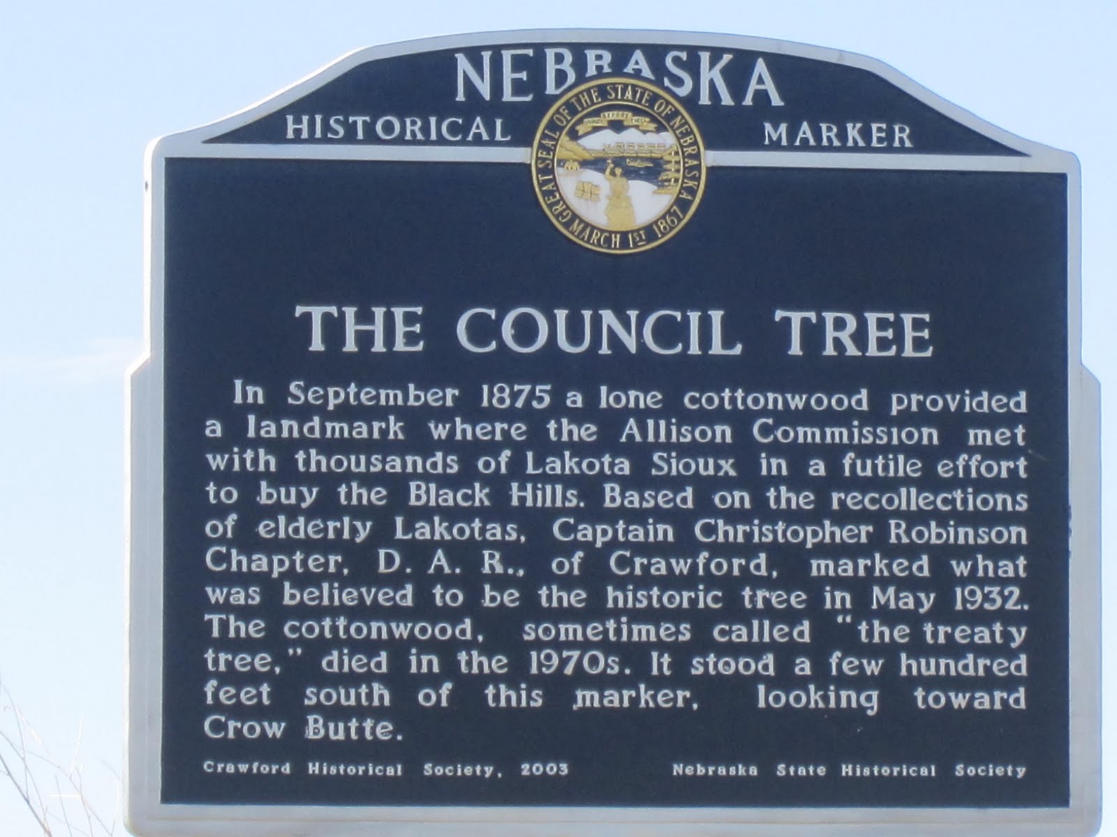
The last part of this historical marker was for the Treaty Tree. The text on the sign was intriguing so I decided to detour the one mile north to try and find the tree. After bouncing down a rough, rutted, and dusty road I found another historic marker essentially saying the same thing – although this time referring to it as the Council Tree.


A more recent stone marker further elaborated the story.


Looking across the farmland I imagined September 1875 and thousands of Native Americans with a small delegation of government officials being camped on this very plain. Under a cottonwood tree a series of discussions and negations occurring because of a broken promise to keep the settlers out of the sacred Black Hills. I felt it must have been a courageous decision to turn down the money (but how can you ever place a monetary value of sacred lands?) knowing that perhaps a bleak future may eventually result. I was glad I stopped to explore a tree now gone but with markers to tell a sad overlooked story in American history.

 
I carried onwards and was soon at another historic landmark – but this one was far more extensive than just a roadside sign.

I collected a brochure about this place which is described as: "one of the great historic places of the American West." A little more detail on the history.


Camp Robinson was one of several army posts established to protect Indian agencies. The US Government in establishing agencies (the forerunner to reservations) promised to provide protection from settlers and others wanting land or wishing to cause harm to Native Americans and their property. From 1874 to 1878, the post provided security for nearby Red Cloud Agency as well as being home for some 11,000 Indians from the northern plains. The death of the great Sioux Chief Crazy Horse occurred at the Fort on September 5 1877. The soldiers also guarded the Sidney-Deadwood Trail which was an important overland route to the Black Hills and the surrounding region. Although the agency was moved in 1877 to southern South Dakota and renamed the Pine Ridge Reservation Camp Robinson remained. As an indication of its permanent status, the designation "Camp" was changed to "Fort" in 1878. The mid-1880s brought a critical change to the history of Fort Robinson. The Fremont, Elkhorn & Missouri Valley Railroad passed through the area and the army decided to expand the post. The railroad gave Fort Robinson a new strategic importance as soldiers from the post could quickly be transported to trouble spots across the mid-section of the US. In the late 1880s the fort was greatly enlarged and replaced Fort Laramie, Wyoming, as the most important military post in the region. Another significant event in Fort Robinson's history occurred in 1885, when the first African American soldiers of the Ninth Cavalry arrived. At that time the U.S. Army was totally segregated, with two cavalry regiments composed of black soldiers. From 1887 to 1898 the post was regimental headquarters for the Ninth Cavalry. During the years 1885 through 1907 the majority of the troops stationed at Fort Robinson were African American.

The massive parade grounds at Fort Robinson.

Soldiers from Fort Robinson served in the conflicts on the Pine Ridge Indian Reservation during the 1890s. They were also sent to help quell several outbreaks of civil disorder during the 1890s. After 1900 the fort continued as regimental headquarters for the Tenth (the other black cavalry regiment), Eighth, and Twelfth Cavalry regiments. In 1916 the remaining units at Fort Robinson were transferred for duty along the Mexican border. The post was virtually abandoned throughout the World War I years. In 1919 Fort Robinson gained new life as a quartermaster remount depot. The Quartermaster Corps was the branch of the U.S. Army responsible for supplies, equipment, and animals (horses, mules, and dogs). As a remount depot the post became an animal processing center for the cavalry and horse drawn artillery. The Fort was the primary location in the country were horses were received, examined, cared for, trained, and eventually issued to mounted army units throughout the national and at service overseas. Other military functions were carried on at the post during the remount period. From 1928 to 1931 the Fourth Field Artillery, a pack-artillery battalion, was headquartered here. From 1933 to 1935 the post served as a Civilian Conservation Corps camp, regional headquarters, and hospital center.

The row of offices houses at Fort Robinson.
 
The busiest years at Fort Robinson were those of World War II. As the nature of the conflict using new technology and tactics most cavalry regiments were dismounted. This resulted in large numbers of horses shipped to the remount depot. By 1943 there were 12,000 horses at Fort Robinson. Here the horse herd was gradually surplused. But the training of pack mules at the post greatly increased during the war years. By the end of the war nearly 10,000 mules had been trained or issued. In the fall of 1942 a K-9 Corps reception and training center was established at the fort. Until war's end, more than 14,000 dogs for the army, army air force, navy, coast guard, and civilian agencies were trained here. In 1943 a prisoner of war camp was constructed on the military reservation between the post and town of Crawford. The POW camp was built to house German 3,000 prisoners. The first prisoners to arrive at Fort Robinson came from Rommel's Tenth Panzer Division in North Africa. Riding the train from Northampton, Virginia, the German POWs arrived on November 19, 1943.

After the war the various military activities at the post were phased out. In 1947 the army decided to abandon Fort Robinson after 73 years of use. The old post was transferred to the United States Department of Agriculture for use as a beef research station. The U.S.D.A. operations continued at the fort until the early 1970s. From the 1950s onwards many of the old buildings needed much maintenance. Often it was decided it was more cost effective simply to demolish which eventually led to efforts to preserve the fort as a historic site and recreational park. The Nebraska State Historical Society established a branch museum here in 1955. About the same time Fort Robinson State Park was created in a part of the old post area. After the beef research operation was phased out, the remaining post area and military reservation was transferred to the state of Nebraska for public use as a state park.

Driving around the old fort it was hard not to be impressed as the size of the place – and also its remoteness. A recurring theme that was to repeat numerous times on this cross country trip was that much history occurred in this place.

 
The character of the landscapes now changed as a continued west along the far northwest corner of Nebraska. I got the photo I was hoping for – a herd of bison (also known as buffalo) on the Great Plains. Imagine the days of immense herds of these majestic animals stretching for as far as the eye could see.


Bison on the Great Plains - between Fort Robinson and Harrison.
 
Then at the little town of Harrison almost at the border of Wyoming I turned south along a desolate stretch of Highway heading for a fascinating visit to Agate Fossil Beds National Monument.

It doesn't get much more desolate than this – Nebraska Highway 29 south of Harrison.


The main features of this National Monument run by the National Park Service are located in a valley of the Niobrara River. Two small bluffs known as Carnegie Hill and University Hill produced some of the most important fossils finds from the Miocene era (the geologic period from 23 to 5 million years before the present). The visitor's center had an amazing collection of fossils from the site, including Miohippus, an ancestor of the modern horse, Menoceras, a pony-sized rhinoceros, Amphicyon, a massive dog that ate bears called Daeodon, Entelodont, a giant pig-like animal, and Stenomylus, a type of camel.


The site is also famous for fossils of Palaeocastor. These were originally thought to be the fossilized remains of plants but it is now proved to be the corkscrew-shaped burrows of a long extinct beaver. I went for a walk into the hills to see these (it was somewhat amusing protected from the elements by what looked like a plastic telephone booth.


But in addition to the fossils there is another element to the history of Agate Beds National Monument. I've copied the following from the National Park website. Originally the land was part of Agate Springs Ranch, a working cattle ranch, owned by Capt. James Cook [not the same guy as the explorer who claimed New Zealand for the British in 1769]. When James Cook first arrived in this area, he chanced to meet Red Cloud of the Oglala Lakota Sioux. They were able to communicate with sign language and over the years James learned some of the spoken language as well. The chance encounter led to a lifelong friendship which resulted in visits to Cook's ranch by Red Cloud and his people. The Sioux traveled 150 miles by horse and wagon from the Pine Ridge Reservation in South Dakota for these visits to Cook's Agate Springs Ranch in Nebraska. They needed a pass to leave the reservation and needed the pass to return to it. Once they had settled into their camp they worked for James Cook, hunted, and held traditional dances and ceremonies that were banned on the reservation. Cook noted that "this was more than a "visit", they seemed to melt back to a time when their lives were spent hunting, following game, harvesting native plants, and trading with other people." During these visits, the Lakota and Northern Cheyenne tribes gave gifts to James Cook and his family and received beef and hides in return. Some of the gifts were made especially for the Cooks including buckskin suits and gloves. Other items were very special, such as a shirt which had belonged to Chief Red Cloud, three generations of peace pipe bags (one belonging to Red Cloud, his father, and his son), and sharpening stone from Chief Crazy Horse.

 
James Cook and his descendants concluded that these gifts should remain in the immediate area of the ranch. When the National Park Service constructed the current visitor center in the early 1990s, it designated two rooms for the display of the James H. Cook Collection. It was an incredible collection and I thanked the foresight of the Cook family for looking after these treasures so well and insisting that they remain close to the land where they were received as gifts.

   
I carried on south on an increasingly warm day passing through Mitchell, crossing the mighty North Platte River, and onto the historic route of the wagons following the Oregon Trail. My first experiences in the US were working on the Mt. Hood National Forest. This was one of the last sections of the 2,000 mile journey for an estimated 400,000 settlers on their overland trail from St. Louis to Portland. So, I was interested to visit a famous stopping place that the pioneers reached much earlier in their struggle westwards.


  Oregon Trail wagon beneath Scotts Bluff.


Scotts Bluff National Monument protects an impressive looking bluff that was an important 19th century landmark on the Oregon Trail. The bluff called Scotts Bluff rises over 830 feet (330 m) above the plains at its highest point. The collection of bluffs was first charted by non-native people in 1812 by the Astorian Expedition of fur traders traveling along the river. The expedition party noted the bluffs as the first large rock formations along the river where the Great Plains started giving way to the foothills of the Rocky Mountains. Their findings were not widely communicated, however, because of the War of 1812. In 1823 the route to the Rocky Mountains was rediscovered, and the bluffs became a regular landmark for fur traders in the region. The most prominent bluff was named after a fur trader named Hiram Scott who died near the bluff in 1828. Fur traders, missionaries, and military expeditions began regular trips past Scotts Bluff during the 1830s. Beginning in 1841, multitudes of settlers passed by Scotts Bluff on their way west on the Oregon Trail with wagon trains using the bluff as a major landmark for navigation across a largely featureless plain. Use of the route tapered off in 1869 when the trail was made obsolete by the completion of the transcontinental railroad. Scotts Bluff and several nearby bluffs were proclaimed a National Monument on December 12, 1919, and placed under the National Park Service which had been created just three years prior.


I paid a visit to the Oregon Trail Museum and Visitor Center built at the base of the bluff. The interesting exhibits told the story of the geology but mostly focused on the westward expansion of the US and the experiences of the pioneers. It is amazing to think my journey from Minneapolis to California would take me a leisurely 6 days whereas the average time for a wagon to traverse the Oregon Trail was 130 days.


After a world class BBQ sausage sandwich in the nearby town of Gering I continued south on Highway 71 then west again on County Road 88 to cross from Nebraska into Wyoming.


Along this stretch on my journey I passed many small fenced in enclosures located in the farm fields but close to the road. After my visit to the Minute Man National Historic Site in South Dakota I recognized what these were – still active nuclear armed missile silos. It is hard to imagine the scene if you were passing this very spot if one of these were to be launched. Explosive gas generators would blast open the 80-ton doors covering the missile silos, and the nuclear-tipped Minutemen would begin streaking toward targets half a world away. I would not want to be where I took this photo when that happens (in fact, I don't want to be anywhere when this happens so let's hope it never does).

One of 450 nuclear-armed ICBMs that remain on active alert in three "fields" throughout the central United States. This one close to the Nebraska/Wyoming border on County Road 88 is controlled from Warren Airforce Base in Wyoming.


On my diagonal cut across the southeast corner I firstly drove through the small town of La Grange, a town which according to Wikipedia has just 322 residents and is home to a large Bible College of just 220 students whose buildings dominated the downtown. Another hour and I was into Cheyenne, the capital and largest city of Wyoming. Having really enjoyed my tour of the state capital in Pierre, South Dakota I decided to repeat the experience.

 Wyoming State capitol.

Because of Wyoming's location at the intersection of the Louisiana Purchase, the Oregon Country, and the Mexican Cession, the land which became Wyoming has a complicated history of territorial relationships. Portions of the territory which became Wyoming were at various points associated with Washington, Oregon, Idaho, Dakota, Nebraska, and Utah, and had previously belonged to the independent states of Great Britain, France, Spain, Mexico, and Texas. The Territory of Wyoming was created by Act of Congress on July 25, 1868. It was admitted to the Union as the 44th state on July 10, 1890.


On July 4, 1867, a survey crew platted the site now known as Cheyenne in what was then the Dakota Territory (later Wyoming Territory). This site was chosen as the point at which the Union Pacific Railroad was planned to cross Crow Creek, a tributary of the South Platte River. It was named for the Native American Cheyenne nation ("Shy-an"), one of the most famous and prominent Great Plains tribes. Almost instantly the town attracted settlers who felt the imminent construction of the Union Pacific Railroad through the area would bring prosperity. By the time the first track was built into Cheyenne November 13, 1867, over four thousand people had migrated into the new city. Because Cheyenne sprang up like magic in just four months, it became known as "Magic City of the Plains". Many left with the westward construction of the railroad but those staying were joined by gamblers, saloon owners, thieves, opportunists, prostitutes, displaced cowboys, miners, transient railroad gangs, proper business men, and soldiers from "Camp Cheyenne," (later named F.E. Warren Air Force Base). On December 10, 1869, territorial Governor John Allen Campbell signed a suffrage act into law making Wyoming the first U.S. state to grant women the right to vote. Wyoming thus claims to be the first government in the world to grant women the right to vote [although the US did not grant the right until 1920 making New Zealand the first country to in 1893]. Unlike Colorado to the south, Wyoming never experienced a boom from gold or mineral wealth and today with a population of 544,270 it is the least populated of the 50 states (despite being the 10th largest in size).


The construction of the capitol was authorized in Wyoming Territory in 1886 before statehood was granted. The Ninth Territorial Legislature Assembly specified that the cost should not exceed US$150,000. Governor Francis E. Warren appointed a five-member commission to select and purchase a site in Cheyenne, as well as to select an architect and solicit for construction. The commission selected the architectural firm of David W. Gibbs & Company, which submitted plans and specification, which were accepted in July 1886. The construction contract was awarded to Adam Freick & Brothers, which submitted the lowest bid at $136,275.12. Construction began on September 9, 1886 and was completed by May 1887. As the state grew over the next few decades, the building became increasingly cramped. In 1915, the State Legislative authorized the construction of the House and Senate chambers, which were completed in March 1917.


I collected a free brochure from the public affairs department and began my self-guided tour. The interior of the building features is dominated by a ground-floor rotunda from which the interior of the central dome is directly visible overhead. The dome features blue and green stained glass imported from England. The offices of four of Wyoming's five elected officials— Governor, Secretary of State, Auditor, and Treasurer— have their offices on the ground floor surrounding the rotunda.


The beautiful done inside the rotunda.

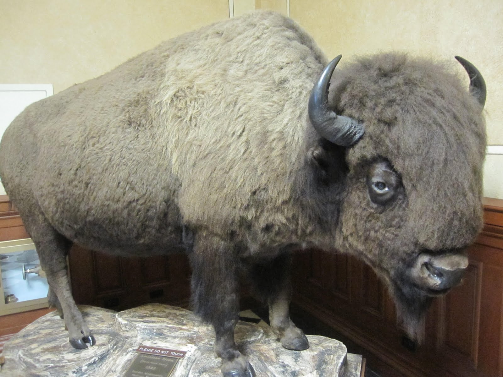
The ground floor contained several large taxidermy specimens of species often associated with Wyoming, including a mounted bison which was raised with the state herd in near the town of Thermopolis. The bison weighed approximately 3,000 lb (1,350 kg) while living, and is the third largest bison recorded.


 Big Bison.
The Senate chamber is the west wing of the second floor building; the House chamber is in the east wing of the second floor. Each chamber contains four impressively large murals by Allen True, who painted them in August 1917 for a cost of $500 each. The murals depict various aspects of the culture, history, and industry of Wyoming. The ceilings of both chambers are inlaid with Tiffany-style stained glass, with the Wyoming State Seal displayed in the center. 


Wyoming State Senate.


The brochure suggested a visit to Legislative Conference Room 302 is a must. Given that the Legislature was not in session I was free to essentially wander about the building. The reason this room is recommended is that a 1,000-lb, Tiffany chandelier, originally located elsewhere in the capitol, hangs beneath a beautiful four-pane stained glass ceiling.


Now late afternoon I had a session of Interstate driving as there really wasn't any alternative routes. I picked up I 25 crossed out of Wyoming and into Colorado skirting Denver's rush hour traffic. As I climbed on west through the foothills of the Rocky Mountains following Interstate 70 I reflected on the journey so far – dominated by the Great Plains. This broad expanse of prairie, farmland, and butte dominated grassland lying west of the Mississippi River and east of the Rocky Mountains plays such a pivotal role in US history. Be it pre-historic such as the fossils I saw at the Agate Beds, incredible eroded landscapes at the Badlands, or the complicated and at times tragic history of conflict between Native Americans and America's desire for westward expansion. That history continues through to the Cold War and the ongoing stationing of the most powerful and destructive weapons ever devised deep within the remote areas of the plains. The distances are vast, the settlements spare, and perhaps lacking in major tourist attractions but I love the Great Plains. To me they represent one of iconic landscapes of America.


I now entered another famous American landscape – the Rocky Mountains. Indeed, mountains would dominate the next chapter of my journey but for now I had only a little further to drive as my destination for the night was wonderful little town called Idaho Springs.


In early January of 1859, George Andrew Jackson, left his winter camp at the site of present-day Golden, Colorado to go on a hunting trip. While camped out on a sandbar where Chicago Creek flows into Clear Creek, Jackson decided to pan some of the thawed gravel around his campfire. Using his drinking cup, he washed out gold nuggets . It was the first substantial gold discovery in Colorado. Jackson, a Missouri native with experience in the California gold fields, was drawn to the area by clouds of steam rising from some nearby hot springs. Jackson kept his find secret for several months, but after he paid for some supplies with gold dust, others rushed to Jackson's diggings. The location was originally known as "Jackson's Diggings" but once the location became a permanent settlement, it was variously called "Idahoe" "Idaho City," and finally "Idaho Springs."  The name Idaho being a based on the word Edauhoe meaning 'gem of the mountains' in the language of the native Arapahoe tribe.


Just like George Jackson it was the hot springs that drew me here. A number of years ago when skiing at the nearby Winter Park resort I came for a soak in the pools. I loved the experience and decided to stay the night at the hotel as it included admission to the pools in the price. They have a large indoor pool as well as these incredible cave baths.

Complete with flowering plants among live banana and palm trees the swimming pool is continually fed with hot mineral water at 115 degrees. With an overall temperature of 90 degrees.


Two tunnels were carved into the solid rock mountain side, between 1903 and 1911, specifically for the purpose of creating this unique "One of a Kind" facility. One cave for men and another for women, each with several huge, sunken, walk-in hot tubs filled with naturally hot mineral water at temperatures from 104 to 112 degrees. I had the tunnel to myself for a really wonderful experience deep within a mountain enjoying the warm water. Needless to say I sleep very well after a long day of driving, seeing more incredible sights and a long hot soak in the thermal waters.