
Sunrise – photo taken while still in my bivy bag at the overnight camp in the rest area.

Sunrise – on the rock walls just south of Moab.
I elected to head the 20 minutes back into Moab for coffee and breakfast. It was a beautifully sunny morning so I then decided to make a quick trip to Arches National Park. I was soon to learn that the landscapes here are so incredibly spectacular that a quick trip is impossible.


Humans have occupied the region since the last ice age 10,000 years ago. Ancient Pueblo People lived in the area up until about 700 years ago. Spanish missionaries encountered Ute and Paiute tribes when they first came through in 1775. Mormons attempted to establish a settlement in 1855 but soon abandoned the area. Ranchers, farmers, and prospectors later settled around Moab in the 1880s. Word of the beauty in the surrounding rock formations spread beyond the settlement as a possible tourist destination. The Arches area was first brought to the attention of the National Park Service by Frank A. Wadleigh, manager of the Denver and Rio Grande Western Railroad who suggested to Park Service director Stephen T. Mather that the area be made a national monument. The following year additional support for the monument idea came from Laurence Gould, a University of Michigan graduate student (and future polar explorer) studying the geology of the nearby La Sal Mountains, who was shown the scenic area. A succession of government investigators examined the area and designation of the area as a national monument was supported President Herbert Hoover in 1929. In 1971 it status was changed to a National Park.
I had a quick look around the visitor's center (always taking time to check the postcards in the gift shop as they show the must see highlights) before heading off to follow the road that leads to the various formations and hiking trails.

A formation known as the 'Three Gossips"


This one was called "Balance Rock"
The story of the geology, and especially the rather complex explanation for the amazing arch formations, can be found here (link to geology of Arches National Park).
It being a beautiful morning, not yet too hot, and being slightly sore after my skiing the day before I wanted to go for a run to shake out the tightness in my legs. I selected the trail to Delicate Arch (a 3 mile / 5 km round trip). I'll provide a little detail of the trail and some of the many photos I took on this incredible run. Right at the trailhead I stopped to look at the remains of Wolfe Ranch and read the interesting interpretative panels describing the history.

John Wesley Wolfe, a veteran of the US Civil War, built the homestead known as Wolfe Ranch around 1898, seeking to make a new life in the newly established State of Utah. The ranch was on a small creek known as Salt Wash, at the beginning of the Delicate Arch Trail. Wolfe and his family lived there a decade or more, then moved back to Ohio. The cabin still remains, an echo of what must have been a very hard life but none the same, a remarkable experience.

Remains of the Wolfe Ranch.
The first third of the hike was through rugged, brushy terrain but following a good trail that gained elevation slightly as incredible views of formations appeared off in the distance.

Early on my run - note the arch on the horizon.
The middle third of the hike was along the face of an exposed slickrock outcrop. This was a lot more strenuous due to the gain in elevation. Given I had run a marathon a month ago I was fairly fit and quickly overtook many of the day hikers who had set off before me.


At times the only way I knew I was on the right path was by following the cairns (piles of rocks) placed to roughly suggest the otherwise unmarked trail to the top.


A wonderful downhill run back to the car before following the road to the far end of the park and then heading off on a second hike to see more of incredible arches.

Sand Dune Arch

Pine Tree Arch

Tunnel Arch
At the end of a 1.5 mile hike I arrived at Landscape Arch - the longest of the many arches in the national park, and by some accounts, the longest natural arch in the world. Across its span it measures 290 feet (88.4 meters).

Landscape Arch
The sign at the base certainly had some incredible information.


Double Arch
I now somewhat relucantly left Arches National Park as I could easily have spent several more hours (if not days) exploring these incredible landscapes. Shortly after leaving the national park I passed by a huge construction site located right beside the Colorado River that I thought had unusually high secuirty. I took a photo and made a note to investiage further.

Moab UMTRA Project.
In 1952 the largest uranium deposit in the United States was discovered here just three miles outside of Moab. With an escalating Cold War the demand for uranium for nuclear weapons and power was at an all time high. The mined uranium was processed with the waste slurry stored in an unlined pond adjacent to the river. After the mill was closed in 1984 the pond was capped. Studies found that waste is leaching into the river, so in August 2005 the Department of Energy announced that 16 million tons of radioactive tailings would be dug up, placed in secure containers, transported 30 miles away along a specially built railway, and buried in a concrete lined hole. The cost of the relocation was originally estimated to be $300 million dollars, but it now stands in excess of $720 million dollars with completion not expected until 2025. It is known as the Moab Uranium Mill Tailings Remedial Action (UMTRA) Project. I couldn't help thinking that the legacy of the Cold War will last a very long time. More on the history and current status of the UMTRA Project can be found here.
I now headed south passing by a beautiful arch some 20 miles south of Moab located right next to the highway - it is called Wilson's Arch named after a pioneer farmer.

Wilson Arch with a span of 91 feet and a height of 46 feet.
I carried on across southern Utah on an increasingly warm day. My destination was another National Park site with incredible rock formations.
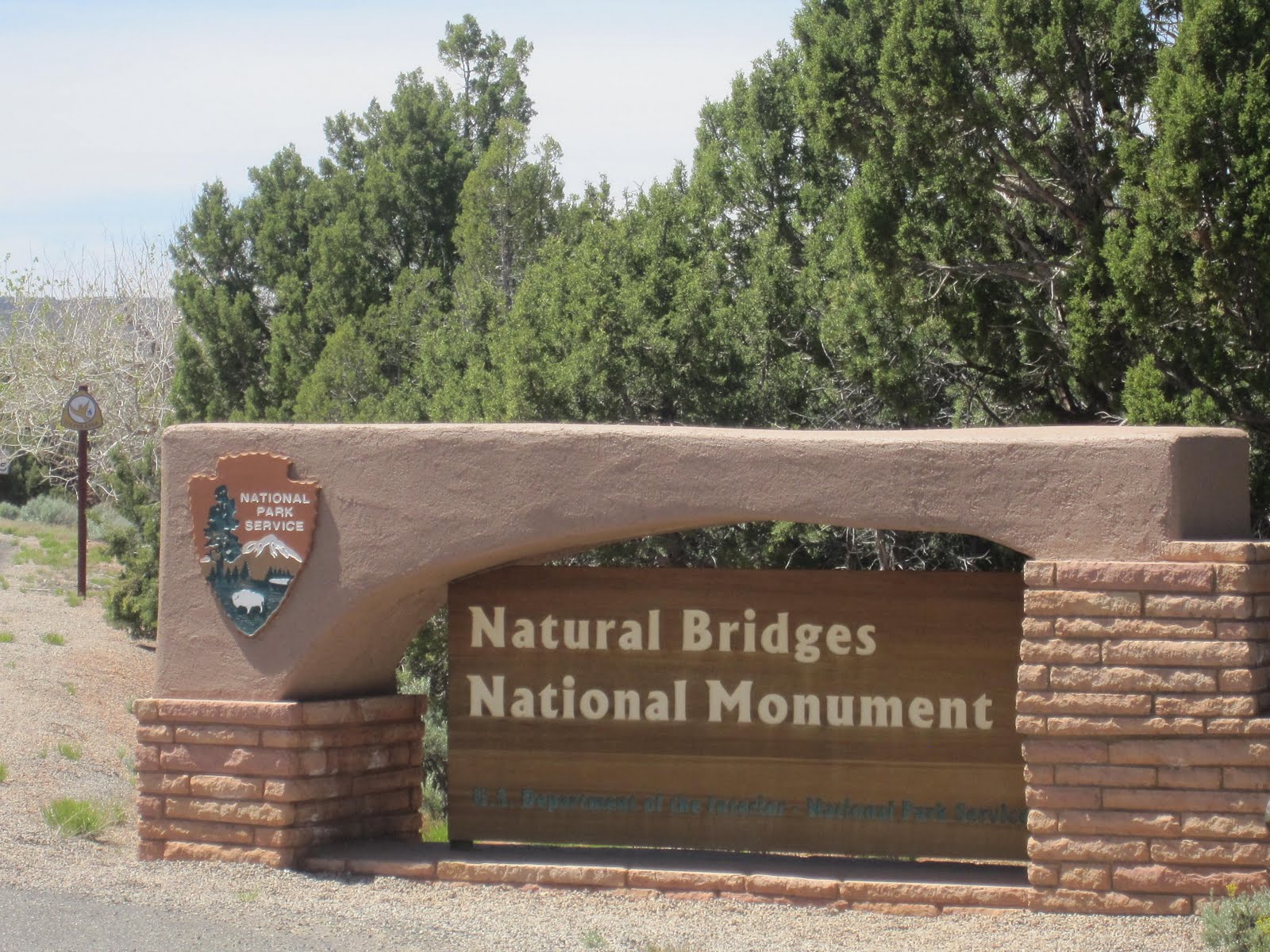

The three bridges in the park are named Kachina, Owachomo, and Sipapu, which are all Hopi names. A natural bridge is formed through erosion by water flowing in the stream bed of the canyon. During periods of flash floods, particularly, the stream undercuts the walls of rock that separate the meanders (or "goosenecks") of the stream, until the rock wall within the meander is undercut and the meander is cut off; the new stream bed then flows underneath the bridge. Eventually, as erosion and gravity enlarge the bridge's opening, the bridge collapses under its own weight. There is evidence of at least two collapsed natural bridges within the Monument.

Owachomo Natural Bridge.
I now turned south across a flat featureless plain until I reached the edge of the world. At least that it what it felt like. I saw a procession of road warning signs before I fully grasped what they were all about.

The Mokee Dugway is a short three miles section of road that was constructed in 1958 by a now-ceased mining operation to transport uranium ore from their mine on top of the mesa to the processing mill on the flat valley below. The three miles of unpaved switchbacks descend 1,100 feet from the top of Cedar Mesa.

Note the road at the top left then on the valley below.
The Moki Dugway is part of Utah Highway 261 about 24 miles south of Natural Bridges National Monument. The Moki Dugway gets its name from the Spanish word ‘moqui’ which was a general term used by the 18th century Spanish explorers and settlers in this region to describe the Pueblo Indians they encountered and the vanished culture which had left behind the numerous ruins they discovered during their travels. This term continued to be used (but spelled mokee or moki) by the Anglo pioneers, who moved into southern Utah during the 1800's to specifically refer to step-like paths they found leading up cliffs to the dwellings of the ancient American Indians. It then became applied to any road or track dug into a cliff face.

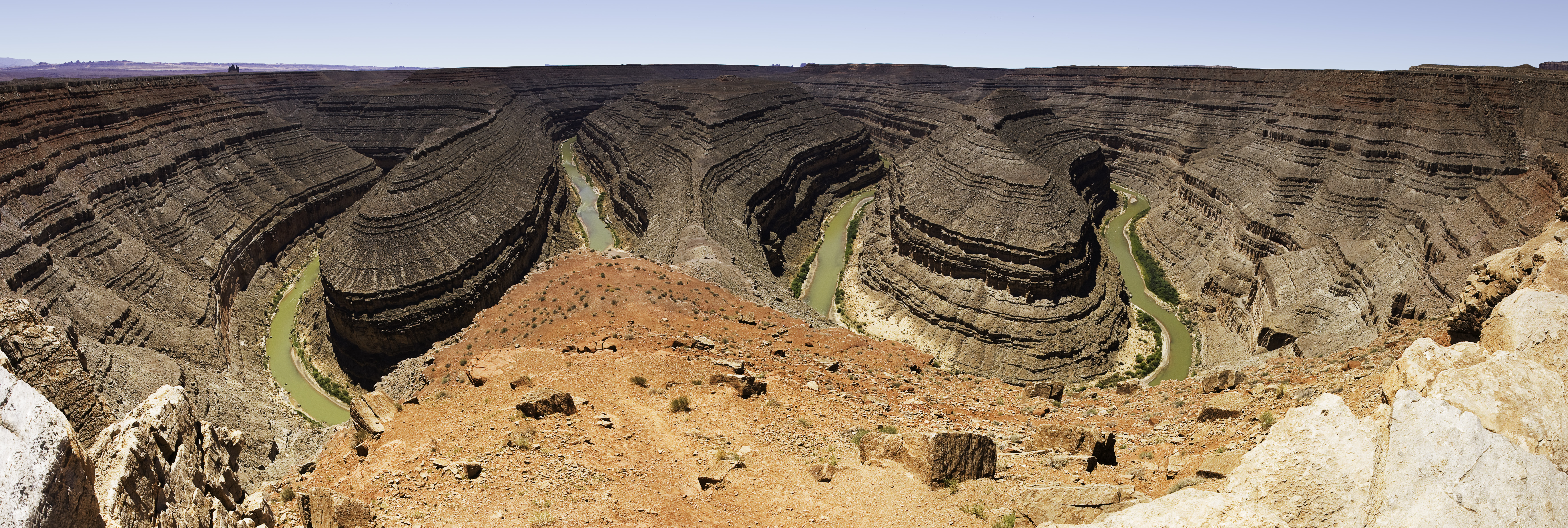
Just five miles further on was yet another geologic wonder. I still remember sitting in a geology class as an undergraduate student in New Zealand seeing pictures of this place. Goosenecks State Park is world famous for being a classic location for observing incised river meanders.

Millions of years ago, the land here was forced upwards causing the river to carve down through the weakest layers of rock. Over a distance of just 1.5 miles the river travels almost 7 miles with the twists and turns.
You need a panoramic camera to get the full effect - so please do click here to see this great panorama of Goosenecks State Park.
Onwards across southern Utah before reaching the town of Mexican Hat for an ice cream and a tank of gas. You maybe wondering how this little town of just 250 people would get such a curious name. This will explain.

I next entered into Monument Valley which would have to be one of the most iconic images in the American West - if not the entire country.

For movie buffs - you may recognize this as the spot where Forest Gump stops running.
I fear I am overly repeating myself in this blog posting - but nothing can prepare you for the sights of Monument Valley. A warm sunny afternoon, windows down, favorite songs on my iPod playing through the car radio created an American experience I'll forever treasure.


Monument Valley is officially part of Monument Valley Navajo Tribal Park, a Navajo Nation equivalent to a national park. Visitors can pay an access fee and drive through the park on a 17-mile dirt road that leads to many of the highest rock towers. But, given the cost and the expected 2-3 hours to do this drive I instead carried on in a southwesterly direction following US 163. I was traveling through the Navajo Nation. This is the largest Native American Reservation in the United States (it is the same size as the state of West Virginia, or a quarter of the size of New Zealand) and is home to 175,000 Navajo People.

Traditional hogan and more modern six sided home on the Navajo Nation.
I was interested to see a mix of contemporary and historic housing on the reservation. The Wikipedia website notes: Most modern housing in the Navajo Nation is detached single-family homes and mobile homes built in the 1960s, 1970s, or 1980s, although older built homes do exist. Single-family homes are mostly rural-styled homes constructed of wood. Because many homes do not have access to natural gas and electricity, most homes use wood or propane for heat and cooking. Due to the reservation's remote geographic location, many structures do not have telephone or public utility services and lack complete kitchen or plumbing facilities. The traditional house structure for the Navajo was a hogan. It is usually round and cone shaped with the door facing the east to welcome the rising sun for good wealth and fortune. They are constructed with stacked logs with dirt pushed into the spaces. Navajos made their hogans in this fashion until the 1900s, when they started to make them in hexagonal and octagonal shape and today some modern housing follows a six-or eight sided construction design. Today, while some older hogans are still used as dwellings and others are maintained for ceremonial purposes, new hogans are rarely intended as family dwellings.


Moenkopi Legacy Inn & Suites Hotel.
Heading on towards the junction of US Highways 160 and 89 then south towards the town of Cameron I could not help but think that the landscapes were beautiful but it must be hard living in this harsh enviroment.


At Cameron I made a spur of the moment decision that I will forever be very thankful for making. The early evening sunlight was painting the land in an ever changing display. I started to think about where I may find a place to spend the night. But as I took a quick look at the map I decided instead to detour into Grand Canyon to watch the sunset. I was a little anxious as I was pretty sure my timing was such that I would miss the main event. Incredibly I reached the first viewpoint on the south rim (a place called Desert View) just in time to see what surely must be one of the most spectacular shows on earth.


I followed the South Rim drive reaching Grand Canyon Village just a few minutes before the store closed at 9:00 pm for a late sandwich and Coke dinner. Then it was south to reach Interstate 40 near the town of Williams and another half hour west before seeing a roadside sign for accommodation in the town of Seligman. Turning off the Interstate I headed onto a remnant section of old Route 66 getting the last available room at a classic old style motel.

No comments:
Post a Comment