I awoke on the forth morning of my cross country odyssey excited for what lay ahead today. I felt a little daft when packing my vehicle in Minnesota on a hot and humid early summer day for the drive to the California Coast when putting in my skis and warm winter clothing. But, I had looked online and saw that there was still skiing to be had in Colorado. Today was going to be a ski day. After a quick breakfast in Idaho Springs I drove about 30 minutes following I70 which parallels Clear Creek passing through a series of old mining towns including Dumont, Georgetown, and Silver Plume.

Old mining relics beside I 70 in Colorado.
Just before the Interstate dives into the Eisenhower Tunnel (which by the way is the highest point on the nations Interstate highway system at 11,158 feet or 3,401 meters above sea level) I turned off onto US Highway 6 for the climb up and over Loveland Pass.

Interstate 70 as it enters into the Eisenhower Tunnel beneath Loveland Ski area.
Loveland Pass, elevation 11,990 ft (3,650 m) above sea level, is a high mountain pass in the Rocky Mountains of northern Colorado. The pass is named for William A. H. Loveland, a resident of Golden during the late 19th century who was president of the Colorado Central Railroad. It is located on the Continental Divide in the Front Range 60 miles west of Denver. U.S. Highway 6 traverses the pass; the twisty road is considered to be especially treacherous during the winter months. A steep, steady 6.7% grade, along with numerous hairpin turns on either side, make it difficult to snowplow the road regularly. Loveland is the highest mountain pass in the world that regularly stays open during a snowy winter season. When the Eisenhower Tunnel opened in March 1973, it allowed motorists on Interstate 70 to avoid crossing the pass directly. Trucks that cannot pass through the tunnel (those carrying hazardous materials and those over 13.92' (4.24 m) in height) must still take US 6 across Loveland Pass, climbing 800 vertical feet (244 m) above the tunnel.

Atop Loveland Pass.

Sign for backcountry skiers at the summit of Loveland Pass.
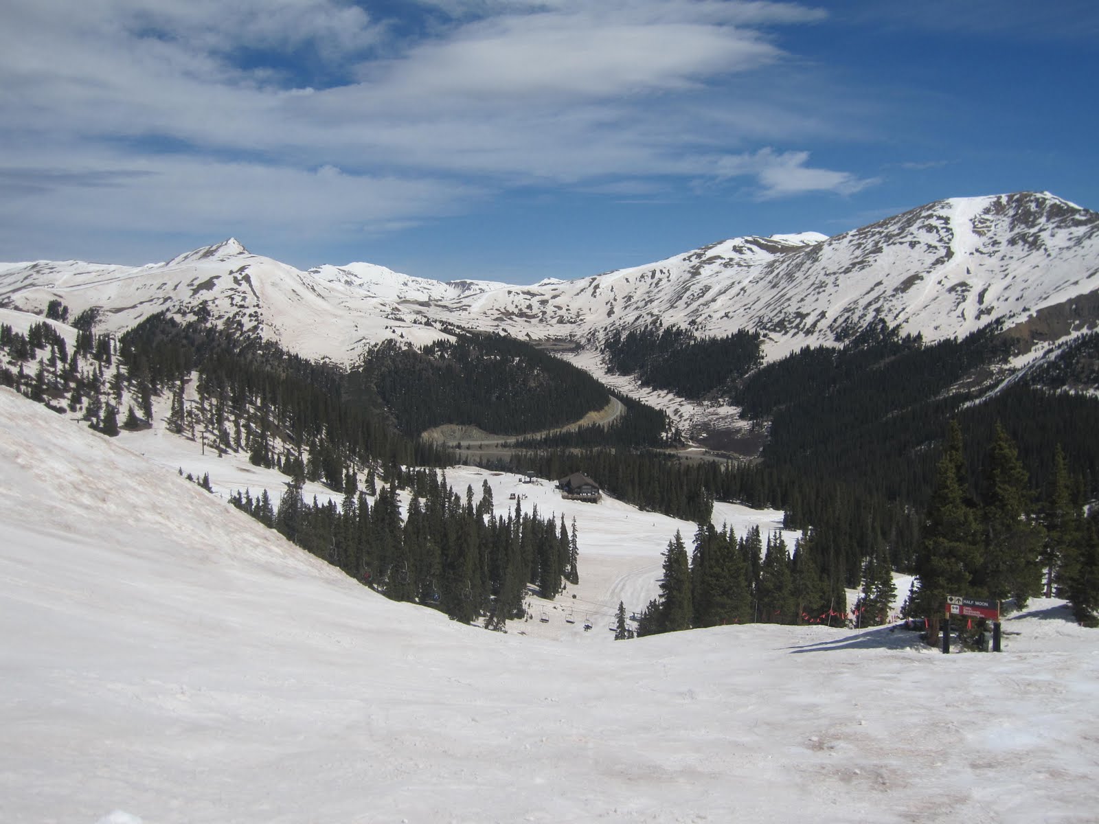
I stopped briefly to admire the view and take a photo of the slopes I would soon be enjoying.

Arapahoe Basin from the top of Loveland Pass.
Arapahoe Basin (but more often referred to as A-Basin or simply, the Basin) is a fairly well-known ski area high in White River National Forest of the Colorado Rocky Mountains. Despite being surrounded by some of the largest and most famous ski areas in the world Arapahoe Basin has a reputation as a smaller Colorado ski area catering for a clientele of hardcore, yet relaxed folks that like simply to ski and avoid the glamour associated with resorts like Aspen and Vail. It is also equally known for its especially long season - staying open until at least June and occasionally early July whereas most other American ski areas close in early May.

My first run of the day heading up the chairlift –
note the lack of people.
note the lack of people.
I've found the following interesting article about the couple who started A-Basin. Max and Edna Dercum started Arapahoe Basin as a small family ski area along with the Ski Tip Lodge in the 1940s. This couple have a pretty interesting history themselves. Edna was born Edna Strand on Aug. 2, 1914 in Clarissa, Minnesota to Norwegian immigrant parents and went to high school in Minneapolis. When her father passed away, she finished her education in Pennsylvania, living with a sister. Later as a student at Penn State University, she became the first woman to join forestry professor Max Dercum's fledgling ski club. As she took up his love of skiing, a romance blossomed between the two, and they married in 1937. She became an accomplished ski racer taking the state downhill and slalom titles in 1941. Her husband's dream of developing a ski mountain in the West brought them to Colorado, and in 1942, they moved to Dillon in Summit County. A couple of years later they bought an 80-acre property for $3,000 that included the Ski Tip Lodge. Max joined a group of five partners to develop Arapahoe Basin, which opened in November of 1946 during the post-war ski boom. (A lift ticket then cost $1.25.) Edna worked as a certified ski instructor for 18 years then worked alongside her husband in the late 1960s when he designed and developed Keystone Ski Resort, which opened in November of 1970. She was still skiing competitively winning the world seniors giant slalom championship at age 65 competing all over North America and Europe, winning medals in Italy and Switzerland. She continued skiing well into her 80s. She passed away in September 2008 at age 94.

The following information comes from the A-Basin website and Wikipedia. Since its opening in 1946 Arapahoe Basin has continually expanded to now include 105 trails over 900 acres served by 7 lifts. The base of the ski area is at 10,780 ft (3,290 m) with a vertical rise of 2,270 ft (6,90 m) with a summit elevation of 13,050 feet (3,977m) [for family and friends reading in New Zealand – this is 734 feet/224 meters higher than our tallest mountain; Aoraki/Mt. Cook]. It is widely regarded as the highest ski-able terrain in North America (although the Telluride resort boasts Palmyra Peak (13,320ft) and Silverton Mountain has terrain up to 13,487 feet). Due to its high altitude (at tree line) and its mostly north to northeast face, A-Basin remains open for skiing much longer than most ski resorts, and often starts earlier as well. In recent years the season has extended from very early October through to early July. Though it is mostly known for advanced and expert terrain, A-Basin also has runs for the novice and intermediate skier. The Pallavicini lift services mostly black and double black terrain on the west side of the mountain. The Pallavicini face itself contains a group of very steep and seemingly endless mogul runs with ratings double black diamond extreme.

The Pallavicini lift and face at A-Basin.
[Note: When I skied here a number of years ago I skied the Pallavivini face and recall it being among the steepest, most demanding, and extreme skiing I've ever done. Let's just say that day at A-Basin a few years back was the first day I have skied with a helmet – a decision I've never regretted. I didn't know where the name Pallavicini came from until I climbed the highest mountain in Austria last year – Grossglockner. On that mountain is a famous (some may say infamous ice gully) that is ridiculous steep. It was first climbed by Alfred Pallavicini in 1876 (although it killed him and the rest of his party as you can read about here). I remember my guide on the summit of Grossglockner pointing out the Pallavicini Route as we climbed by on a much easier route and thinking "Oh – that is where the name at A-Basin comes from"].

From the top of the A-Basin with great views of Lake Dillon
and the ski areas of Breckenridge and Keystone.
On the slopes of A-Basin looking back at Loveland Pass.
It was a warm spring day with only two of the lifts operating but it still gave access to vast acres of terrain. There were very few other skiers and snow boarders with no lift lines at all. It was surprisingly hot (shorts and t-shirt weather) at the base of the mountain but below freezing with a stiff wind blowing by the time you reached the top. Spring skiing means heavy snow which is tiring. Despite an inch of fresh snow within the previous 48 hours by mid afternoon it was quite slushy and my legs were pretty wiped out. I decided to call it a day before tiredness caused an accident. But what a fabulous day of skiing. I am so grateful that my parents introduced me to this sport as a kid in New Zealand. I look back now and absolutely treasure the days skiing at the little ski area of Porters Heights with Mum, Dad, and my sister Rose. I will also treasure my day at A-Basin during my cross-country journey.

Lunchtime chillin' at A- Basin – May 2010.
I rejoined Interstate 70 at Dillion and then passed a series of ski areas: Copper Mountain, Vail, and Beaver Creek. All were closed for the season with just small remnant patches of snow visible.

Not much snow left at Cooper Mountain (which
had closed for the season).
had closed for the season).
Up a fairly steep 7% grade to reach the summit of Vail Pass at 10,662 feet (3,249 m) before dropping down into the drainage of the Eagle River in flood with the spring melt. I passed the massive gypsum mine that gave the city of Gypsum its name. Beside the freeway is a large processing facility where the gypsum is turned into drywall (also called sheetrock or GIB Board). Then the terrain changed greatly as I carried on west through Glenwood Canyon.

Entering Glenwood Canyon.
This rugged and beautifully scenic 12.5 mile (20 km) canyon was carved by the Colorado River in western Colorado. The canyon walls climb as high as 1,300ft (396m) above the river making it the largest canyon on the upper reaches of the Colorado River. The canyon was formed relatively recently in Pleistocene era by the rapid cutting of the Colorado down through layers of sedimentary rock. The canyon stretches from near the town of Dotsero, where the Colorado receives the Eagle River, downstream to just east of Glenwood Springs, on the mouth of the Roaring Fork River.

In the Canyon – railway on the left, two lanes of I 70
on the right, and the mighty Colorado River in the middle.
on the right, and the mighty Colorado River in the middle.

The canyon is widely considered one of the most scenic natural features on the Interstate Highway System of the United States. Glenwood Canyon has served as the primary transportation artery through the Rocky Mountains, even before the creation of U.S. highways. Railroads have used the canyon since 1887 and a dirt road was built through the canyon in 1906. Known as the Taylor State Road, this gravel road through the Glenwood Canyon was the first route for automobiles through the Colorado Rockies. The first paved road was built from 1936 to 1938 at a cost of $1.5 million (equivalent to $23 million today). With the Eisenhower Tunnel finished, the last remaining obstacle for I-70 to be an interstate commercial artery was the two lane, non-freeway portion in Glenwood Canyon. Construction had started on this section in the 1960s with a small section opening to traffic in 1966. The remainder was stopped due to environmentalist protests that caused a 30-year controversy. The original design was criticized as "the epitome of environmental insensitivity". Engineers scrapped the original plans and started work on a new design that would minimize additional environmental impacts. A new design was underway by 1971 which was approved in 1975; however, environmental groups filed lawsuits to stop construction, and the controversy continued even when construction finally resumed in 1981. The final design included 40 bridges and viaducts, three additional tunnel bores (two were completed before construction was stopped in the 1960s) and 15 miles (24 km) of retaining walls for a stretch of freeway 12 miles (19 km) long. The project was further complicated by the need to build the four lane freeway without disturbing the operations of the railroad. This required using special and coordinated blasting techniques. Engineers designed two separate tracks for the highway, one elevated above the other, to minimize the footprint in the canyon. The final design was praised for its environmental sensitivity. A Denver architect who helped design the freeway proclaimed, "Most of the people in western Colorado see it as having preserved the canyon." He further stated, "I think pieces of the highway elevate to the standard of public art." The freeway was finally completed on October 14, 1992 in a ceremony covered by media nationwide. Most coverage celebrated the engineering achievement or noted this was the last major piece of the Interstate Highway System to open to traffic. The cost was $490 million (equivalent to $800 million today) to build 12 miles (19 km), 40 times the average cost per mile predicted by the planners and thus making it the most expensive non-urban freeway in the United States.
It was an incredible stretch of road – not quite sure I agree with the public art comment, but then again it does seem quite fitting. At the west end of the canyon you immediately enter into the town of Glenwood Springs.
The town has a long, interesting history. It was originally known as Defiance, Colorado having been established in 1883, as a collection of tents, saloons, and brothels followed over the coming months with an increasing amount of cabins and lodging establishments. It was populated with the expected crowd of gamblers, gunslingers, and prostitutes. Town founder Isaac Cooper's wife Sarah was having a hard time adjusting to the frontier life and in an attempt to make her environment somewhat more comfortable, persuaded the founders to change the name to Glenwood Springs, Colorado after her beloved hometown of Glenwood, Iowa. Its unique location at the confluence of the Colorado River and the Roaring Fork River as well gaining a stop on the railroad made it a center of commerce in the area. In the late 1800s and into the early 1900s it gained a reputation as a fashionable vacation retreat largely driven by the building of the Colorado Hotel.

The Colorado Hotel in Glenwood Springs.
This hotel was established by silver magnate and banker Walter Devereux. Construction began in 1891 at a cost of $350,000. Edward Lippincott Tilton designed the building as a replica of the Villa de Medici in Rome, Italy. Local materials used include cream-colored Roman brick and Peach Blow Sandstone; imported items included 12,000 yards of carpet and 2,000 rose bushes. The Hotel Colorado opened on June 10, 1893 to a program including a fireworks display, and a full orchestra playing in the ballroom. The hotel quickly became a popular summer retreat, earning the nickname of "the little White House of the West" after extended visits by Presidents Theodore Roosevelt and William Howard Taft. The teddy bear is alleged to have been invented during President Roosevelt's 1905 visit to the Colorado Hotel. To cheer President Roosevelt after an unsuccessful day of hunting, Hotel Colorado maids presented him with a stuffed bear pieced together with scraps of fine material. Later, his daughter Alyce admired it saying, "I will call it Teddy." The term caught on and became the name for one of the world's most popular toys, the Teddy Bear.
I wish I could have afforded the time and money to stay a night at the Colorado Hotel. But, I was drawn to stop at the this town for the same reason that thousands (if not hundreds of thousands) of tourists stop each year – for a soak in the world's largest natural hot pool.

The Glenwood Hot Springs Pool is the largest natural hot springs pool in the world. It is massive at 405 feet long x 100 feet wide making it more than two city blocks long. It contains 1,071,000 gallons of water. A smaller therapy pool is tiny by comparison at 100 feet long x 40 feet wide with only 91,000 gallons. The big pool has water at about 90° F / 32° C whereas, the small therapy pool is kept at a temperature of about 104° F / 40° C. Both pools are directly connect to the Yampah spring located at the eastern end of the property. The spring has a daily flow of 3,500,000 gallons of water, at approximately 122° F/ 51° C.
Thousands of years in the making, the Ute Indians were the first known visitors to the mineral-rich hot springs that flow along the banks of the Colorado River in Glenwood Canyon. They called them "Yampah" meaning "big medicine." In search of these waters with great healing power, Captain Richard Sopris and his party of geographic explorers found the sacred healing spot in 1860. Twenty years later, Walter Horace, James Devereux, and a group of British investors purchased the Yampah Hot Springs along with l0 acres of surrounding land. They set out to harness the 3.5 million gallons of naturally hot mineral water that rises from the source of the spring each day. In 1888 the world's largest hot springs pool was born in the newly established town of Glenwood Springs. It became world-renowned as a healing wonder set in a mountain paradise. Around the turn of the century, the Golden Age of Mineral Spas, it was affectionately known as "Spa of the Rockies", when spa was defined as hot spring bathing. The original red sandstone bathhouse and lodge was built for $100,000 in l890. Designed by Austrian architect Theodore von Rosenberg, the walls of both the pool and the bathhouse were of solid masonry with peach-blow sandstone quarried nearby. The bathhouse featured tubs, Roman vapor baths, special accommodations for pool bathing, a ladies parlor, physician's office, gymnasium, and smoking and reading rooms. Each of the building's 44 bathing rooms included a dressing room and lounge. As word of this new resort spread, aristocrats, political leaders, movie stars, and spiritual believers ventured to Glenwood Springs from around the world. During World War II from 1943 to 1946 the resort, then consisting of the Hotel Colorado and Hot Springs Bathhouse, were used exclusively as a U.S. Naval Convalescent Hospital - the only time in history when it was closed to the public. After the war it was converted into Glenwood Clinic, a private hospital until 1950, and is today known as Glenwood Hot Springs. A new master plan was implemented in l970, including an updated water filtration system, children's wading pool, water slide, and miniature golf. And in l986, a new l07-room Hot Springs Lodge was built just north of the pool. Today the original sandstone lodge is home to the new Spa of the Rockies - a tribute to the resort's magical appeal at the turn of the century.
It was a truly a unique Rocky Mountain swim, perfect after a hard day of skiing. I felt pretty wiped out after a long hot swim, so perhaps where I was headed next will surprise you. Just 10 minutes outside Glenwood Springs is another hot spring, this one could not be more different.

South Canyon Hotspring.
South Canyon Springs is an amazing contrast to the commercial hot springs in Glenwood Springs. South Canyon consists of a two muddy pools located up on a hillside with great views of the surrounding mountains, including a direct view of Storm King Mountain where 14 wild land firefighters were killed in a 1994 blaze (you can read a US Forest Service report about this tragedy here).

View from inside the pool – looking up
towards Storm King Mountain.
towards Storm King Mountain.
The water just bubbles up from the ground (estimated at 112 degrees in a guide book I have that alerted me to this gem of hot spring). The guidebook warned that the conditions of the springs are known to vary – sometimes they are perfect and clear and other times shallow and muddy. For my visit larger pool was relatively clean and hot but the smaller pool was shallow, gross, and filled with a green scum. Needless to say I focused on the larger of the pools. There were two other locals there and we sat in the hot water talking about other remote hot springs we have enjoyed.

The source of the South Canyon Hot Springs.
I now pushed on still following Interstate 70 through three amusing named towns (Silt, Rifle, and Parachute). I stopped for dinner in this last town, wondering how a place in the dry western valleys of Colorado would be named Parachute. Here is what I discovered. The name comes from the appearance on a map of several streams converging on the town. When combined with the arc of the ridge line above the streams it resembles the canopy of a parachute. Parachute Creek was named when the original surveyors mapped the area. In 1908, the name of the town was changed to Grand Valley to lure travelers on their way to the Grand Valley, which is the Colorado River valley to the southwest known for its fruit production. After the local history "Lest We Forget" was published in the late 1970s the town voted in the 1980s to return the name Parachute to the town. Just south of the town I passed a massive industrial plant which I erroneously thought was oil/or gas related. It turned out to be a recently mothballed chemical plant that processed nearby mined soda ash into sodium bicarbonate (i.e., baking soda).
On westwards following the Colorado River into and then out of Grand Junction. I made a big error by not stopping for the night here as I looked at the map and seeing small towns along my route I decided to push on for just a few more miles towards California. But all too quickly I realized that after a day of skiing, two swims in very hot mineral water, and many miles of driving I was getting very tired. I pushed on expecting to see signs for accommodation – but nothing. Then across the border into Utah and still nothing.

I bought gas at a little place called Thompson Springs. The guy at the gas station told me my options for a motel were to turn around and drive the 80 miles back to Grand Junction, or carry on for another 20 miles towards Green Valley (although this had few options for motels/hotels) or drive 30 miles south on US 191 to Moab which he said has lots of accommodation options. Based solely on his recommendation I chose the latter option. He was right, (sort of) as I was presented with a sea of well-lit motel and hotel signs as I approached Moab which made my weary sprits soar. But, one by one I checked each motel and hotel only to be told they had no vacancies. I asked one very friendly chap if he might know of any place in town that might have a vacancy. I stood by nervously as he made several telephone calls to his hospitality colleagues. I heard him say "One – great, yes just one person for one night". I was so relieved to think I would soon be able to fall on a soft bed and finally get some sleep. Then he told me it was the only room in town and it was the suite at a hotel and it could be mine for just $159, plus tax. Well, that was just too expensive.
So despondently I headed on south out of Moab hoping the next town would provide better luck. But after just a few miles I was over-come with tiredness. I saw a roadside rest area filled with RVs and huge trucks and decided the safest thing to do was to pull over. I was going to sleep in the van but I had it fairly well packed, all the RVs and trucks had their generators running producing a most irritating orchestrated din, and finally the rest area was lit with flood lights so bright I'm sure you would be able to pick out this remote spot in Utah from the surface of the moon. My tent and sleeping bag were already in California so I resigned myself to sleeping on my air mattress with my bivy bag beside a picnic table. It now being just after 11:00pm, I was asleep in no time.

Bed for the night.
At exactly 2:15 in the morning I suddenly felt water failing on me. In my exhausted state I just assumed it was raining. However, I was under the picnic shelter. The "rain" was driving in on me with some of the biggest raindrops I've ever seen outside of the tropics. Then it would seem to stop and move off only to return some 30 seconds later. It wasn't quite adding up as my half-sleeping brain. I struggled to connect why in the middle of desert, on a bright moonlit night while lying under a roofed picnic area I was getting drenched in the rain. Yes, that's right – I had lain down in a place where the automatic sprinklers could reach me. Once re-situated to the other side of the picnic area it was back to sleep – be it a little wetter than I planned.

Morning showing my accommodations in the rest area
south of Moab,
south of Moab,
complete with unwanted midnight shower.
No comments:
Post a Comment