Chadron was a pleasant place to spend the night. The next morning, after a great breakfast with the local farmers at a main street café, I continued heading west out of town following US Highway 20. The scenery and the day were both fantastic. Incredible green fields stretching across the plains to abut clay buttes with their flanks covered in pine forests rising abruptly from the farmland.

Amazing country near Chadron, Nebraska.
About 30 minutes from Chadron I pulled over to view a roadside historical marker. One of the things I love about traveling off the Interstate Freeways and along the slower highways are the historical markers that dot the country side. Usually with signed notification a mile in advance you discover a historical, geologic, or cultural story related to the place, or nearby location. I always try to stop and read roadside markers as it adds so much towards a greater understanding and appreciation of the countryside.

The last part of this historical marker was for the Treaty Tree. The text on the sign was intriguing so I decided to detour the one mile north to try and find the tree. After bouncing down a rough, rutted, and dusty road I found another historic marker essentially saying the same thing – although this time referring to it as the Council Tree.
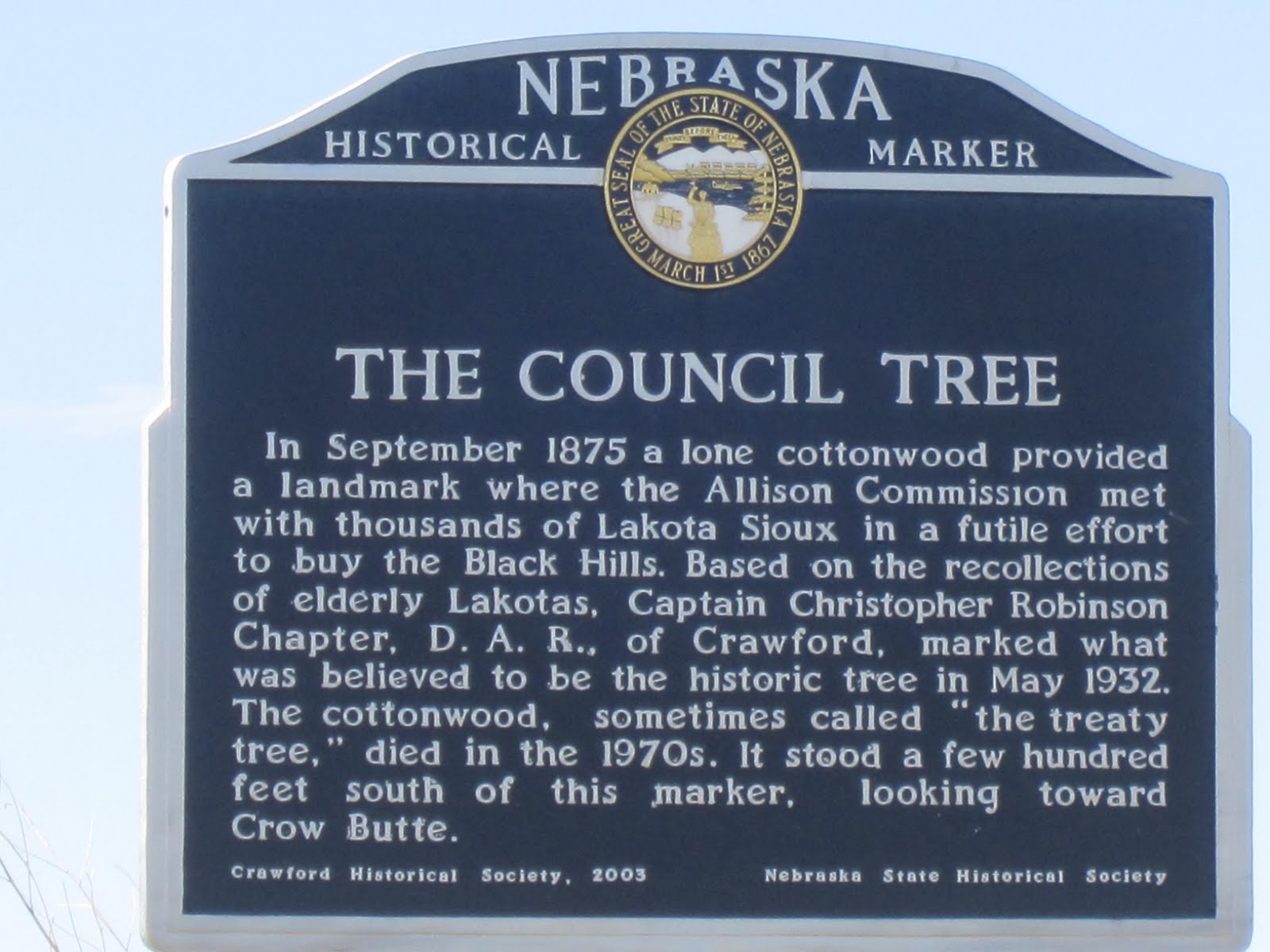
A more recent stone marker further elaborated the story.


Looking across the farmland I imagined September 1875 and thousands of Native Americans with a small delegation of government officials being camped on this very plain. Under a cottonwood tree a series of discussions and negations occurring because of a broken promise to keep the settlers out of the sacred Black Hills. I felt it must have been a courageous decision to turn down the money (but how can you ever place a monetary value of sacred lands?) knowing that perhaps a bleak future may eventually result. I was glad I stopped to explore a tree now gone but with markers to tell a sad overlooked story in American history.
I carried onwards and was soon at another historic landmark – but this one was far more extensive than just a roadside sign.

I collected a brochure about this place which is described as: "one of the great historic places of the American West." A little more detail on the history.
Camp Robinson was one of several army posts established to protect Indian agencies. The US Government in establishing agencies (the forerunner to reservations) promised to provide protection from settlers and others wanting land or wishing to cause harm to Native Americans and their property. From 1874 to 1878, the post provided security for nearby Red Cloud Agency as well as being home for some 11,000 Indians from the northern plains. The death of the great Sioux Chief Crazy Horse occurred at the Fort on September 5 1877. The soldiers also guarded the Sidney-Deadwood Trail which was an important overland route to the Black Hills and the surrounding region. Although the agency was moved in 1877 to southern South Dakota and renamed the Pine Ridge Reservation Camp Robinson remained. As an indication of its permanent status, the designation "Camp" was changed to "Fort" in 1878. The mid-1880s brought a critical change to the history of Fort Robinson. The Fremont, Elkhorn & Missouri Valley Railroad passed through the area and the army decided to expand the post. The railroad gave Fort Robinson a new strategic importance as soldiers from the post could quickly be transported to trouble spots across the mid-section of the US. In the late 1880s the fort was greatly enlarged and replaced Fort Laramie, Wyoming, as the most important military post in the region. Another significant event in Fort Robinson's history occurred in 1885, when the first African American soldiers of the Ninth Cavalry arrived. At that time the U.S. Army was totally segregated, with two cavalry regiments composed of black soldiers. From 1887 to 1898 the post was regimental headquarters for the Ninth Cavalry. During the years 1885 through 1907 the majority of the troops stationed at Fort Robinson were African American.

The massive parade grounds at Fort Robinson.

The row of offices houses at Fort Robinson.
After the war the various military activities at the post were phased out. In 1947 the army decided to abandon Fort Robinson after 73 years of use. The old post was transferred to the United States Department of Agriculture for use as a beef research station. The U.S.D.A. operations continued at the fort until the early 1970s. From the 1950s onwards many of the old buildings needed much maintenance. Often it was decided it was more cost effective simply to demolish which eventually led to efforts to preserve the fort as a historic site and recreational park. The Nebraska State Historical Society established a branch museum here in 1955. About the same time Fort Robinson State Park was created in a part of the old post area. After the beef research operation was phased out, the remaining post area and military reservation was transferred to the state of Nebraska for public use as a state park.
Driving around the old fort it was hard not to be impressed as the size of the place – and also its remoteness. A recurring theme that was to repeat numerous times on this cross country trip was that much history occurred in this place.
The character of the landscapes now changed as a continued west along the far northwest corner of Nebraska. I got the photo I was hoping for – a herd of bison (also known as buffalo) on the Great Plains. Imagine the days of immense herds of these majestic animals stretching for as far as the eye could see.


Bison on the Great Plains - between Fort Robinson and Harrison.
Then at the little town of Harrison almost at the border of Wyoming I turned south along a desolate stretch of Highway heading for a fascinating visit to Agate Fossil Beds National Monument.

It doesn't get much more desolate than this – Nebraska Highway 29 south of Harrison.
The main features of this National Monument run by the National Park Service are located in a valley of the Niobrara River. Two small bluffs known as Carnegie Hill and University Hill produced some of the most important fossils finds from the Miocene era (the geologic period from 23 to 5 million years before the present). The visitor's center had an amazing collection of fossils from the site, including Miohippus, an ancestor of the modern horse, Menoceras, a pony-sized rhinoceros, Amphicyon, a massive dog that ate bears called Daeodon, Entelodont, a giant pig-like animal, and Stenomylus, a type of camel.


The site is also famous for fossils of Palaeocastor. These were originally thought to be the fossilized remains of plants but it is now proved to be the corkscrew-shaped burrows of a long extinct beaver. I went for a walk into the hills to see these (it was somewhat amusing protected from the elements by what looked like a plastic telephone booth.


But in addition to the fossils there is another element to the history of Agate Beds National Monument. I've copied the following from the National Park website. Originally the land was part of Agate Springs Ranch, a working cattle ranch, owned by Capt. James Cook [not the same guy as the explorer who claimed New Zealand for the British in 1769]. When James Cook first arrived in this area, he chanced to meet Red Cloud of the Oglala Lakota Sioux. They were able to communicate with sign language and over the years James learned some of the spoken language as well. The chance encounter led to a lifelong friendship which resulted in visits to Cook's ranch by Red Cloud and his people. The Sioux traveled 150 miles by horse and wagon from the Pine Ridge Reservation in South Dakota for these visits to Cook's Agate Springs Ranch in Nebraska. They needed a pass to leave the reservation and needed the pass to return to it. Once they had settled into their camp they worked for James Cook, hunted, and held traditional dances and ceremonies that were banned on the reservation. Cook noted that "this was more than a "visit", they seemed to melt back to a time when their lives were spent hunting, following game, harvesting native plants, and trading with other people." During these visits, the Lakota and Northern Cheyenne tribes gave gifts to James Cook and his family and received beef and hides in return. Some of the gifts were made especially for the Cooks including buckskin suits and gloves. Other items were very special, such as a shirt which had belonged to Chief Red Cloud, three generations of peace pipe bags (one belonging to Red Cloud, his father, and his son), and sharpening stone from Chief Crazy Horse.
James Cook and his descendants concluded that these gifts should remain in the immediate area of the ranch. When the National Park Service constructed the current visitor center in the early 1990s, it designated two rooms for the display of the James H. Cook Collection. It was an incredible collection and I thanked the foresight of the Cook family for looking after these treasures so well and insisting that they remain close to the land where they were received as gifts.

I carried on south on an increasingly warm day passing through Mitchell, crossing the mighty North Platte River, and onto the historic route of the wagons following the Oregon Trail. My first experiences in the US were working on the Mt. Hood National Forest. This was one of the last sections of the 2,000 mile journey for an estimated 400,000 settlers on their overland trail from St. Louis to Portland. So, I was interested to visit a famous stopping place that the pioneers reached much earlier in their struggle westwards.

Oregon Trail wagon beneath Scotts Bluff.
Scotts Bluff National Monument protects an impressive looking bluff that was an important 19th century landmark on the Oregon Trail. The bluff called Scotts Bluff rises over 830 feet (330 m) above the plains at its highest point. The collection of bluffs was first charted by non-native people in 1812 by the Astorian Expedition of fur traders traveling along the river. The expedition party noted the bluffs as the first large rock formations along the river where the Great Plains started giving way to the foothills of the Rocky Mountains. Their findings were not widely communicated, however, because of the War of 1812. In 1823 the route to the Rocky Mountains was rediscovered, and the bluffs became a regular landmark for fur traders in the region. The most prominent bluff was named after a fur trader named Hiram Scott who died near the bluff in 1828. Fur traders, missionaries, and military expeditions began regular trips past Scotts Bluff during the 1830s. Beginning in 1841, multitudes of settlers passed by Scotts Bluff on their way west on the Oregon Trail with wagon trains using the bluff as a major landmark for navigation across a largely featureless plain. Use of the route tapered off in 1869 when the trail was made obsolete by the completion of the transcontinental railroad. Scotts Bluff and several nearby bluffs were proclaimed a National Monument on December 12, 1919, and placed under the National Park Service which had been created just three years prior.
I paid a visit to the Oregon Trail Museum and Visitor Center built at the base of the bluff. The interesting exhibits told the story of the geology but mostly focused on the westward expansion of the US and the experiences of the pioneers. It is amazing to think my journey from Minneapolis to California would take me a leisurely 6 days whereas the average time for a wagon to traverse the Oregon Trail was 130 days.

After a world class BBQ sausage sandwich in the nearby town of Gering I continued south on Highway 71 then west again on County Road 88 to cross from Nebraska into Wyoming.

Along this stretch on my journey I passed many small fenced in enclosures located in the farm fields but close to the road. After my visit to the Minute Man National Historic Site in South Dakota I recognized what these were – still active nuclear armed missile silos. It is hard to imagine the scene if you were passing this very spot if one of these were to be launched. Explosive gas generators would blast open the 80-ton doors covering the missile silos, and the nuclear-tipped Minutemen would begin streaking toward targets half a world away. I would not want to be where I took this photo when that happens (in fact, I don't want to be anywhere when this happens so let's hope it never does).

On my diagonal cut across the southeast corner I firstly drove through the small town of La Grange, a town which according to Wikipedia has just 322 residents and is home to a large Bible College of just 220 students whose buildings dominated the downtown. Another hour and I was into Cheyenne, the capital and largest city of Wyoming. Having really enjoyed my tour of the state capital in Pierre, South Dakota I decided to repeat the experience.

Wyoming State capitol.
Because of Wyoming's location at the intersection of the Louisiana Purchase, the Oregon Country, and the Mexican Cession, the land which became Wyoming has a complicated history of territorial relationships. Portions of the territory which became Wyoming were at various points associated with Washington, Oregon, Idaho, Dakota, Nebraska, and Utah, and had previously belonged to the independent states of Great Britain, France, Spain, Mexico, and Texas. The Territory of Wyoming was created by Act of Congress on July 25, 1868. It was admitted to the Union as the 44th state on July 10, 1890.

On July 4, 1867, a survey crew platted the site now known as Cheyenne in what was then the Dakota Territory (later Wyoming Territory). This site was chosen as the point at which the Union Pacific Railroad was planned to cross Crow Creek, a tributary of the South Platte River. It was named for the Native American Cheyenne nation ("Shy-an"), one of the most famous and prominent Great Plains tribes. Almost instantly the town attracted settlers who felt the imminent construction of the Union Pacific Railroad through the area would bring prosperity. By the time the first track was built into Cheyenne November 13, 1867, over four thousand people had migrated into the new city. Because Cheyenne sprang up like magic in just four months, it became known as "Magic City of the Plains". Many left with the westward construction of the railroad but those staying were joined by gamblers, saloon owners, thieves, opportunists, prostitutes, displaced cowboys, miners, transient railroad gangs, proper business men, and soldiers from "Camp Cheyenne," (later named F.E. Warren Air Force Base). On December 10, 1869, territorial Governor John Allen Campbell signed a suffrage act into law making Wyoming the first U.S. state to grant women the right to vote. Wyoming thus claims to be the first government in the world to grant women the right to vote [although the US did not grant the right until 1920 making New Zealand the first country to in 1893]. Unlike Colorado to the south, Wyoming never experienced a boom from gold or mineral wealth and today with a population of 544,270 it is the least populated of the 50 states (despite being the 10th largest in size).
The construction of the capitol was authorized in Wyoming Territory in 1886 before statehood was granted. The Ninth Territorial Legislature Assembly specified that the cost should not exceed US$150,000. Governor Francis E. Warren appointed a five-member commission to select and purchase a site in Cheyenne, as well as to select an architect and solicit for construction. The commission selected the architectural firm of David W. Gibbs & Company, which submitted plans and specification, which were accepted in July 1886. The construction contract was awarded to Adam Freick & Brothers, which submitted the lowest bid at $136,275.12. Construction began on September 9, 1886 and was completed by May 1887. As the state grew over the next few decades, the building became increasingly cramped. In 1915, the State Legislative authorized the construction of the House and Senate chambers, which were completed in March 1917.
I collected a free brochure from the public affairs department and began my self-guided tour. The interior of the building features is dominated by a ground-floor rotunda from which the interior of the central dome is directly visible overhead. The dome features blue and green stained glass imported from England. The offices of four of Wyoming's five elected officials— Governor, Secretary of State, Auditor, and Treasurer— have their offices on the ground floor surrounding the rotunda.

The beautiful done inside the rotunda.
The ground floor contained several large taxidermy specimens of species often associated with Wyoming, including a mounted bison which was raised with the state herd in near the town of Thermopolis. The bison weighed approximately 3,000 lb (1,350 kg) while living, and is the third largest bison recorded.
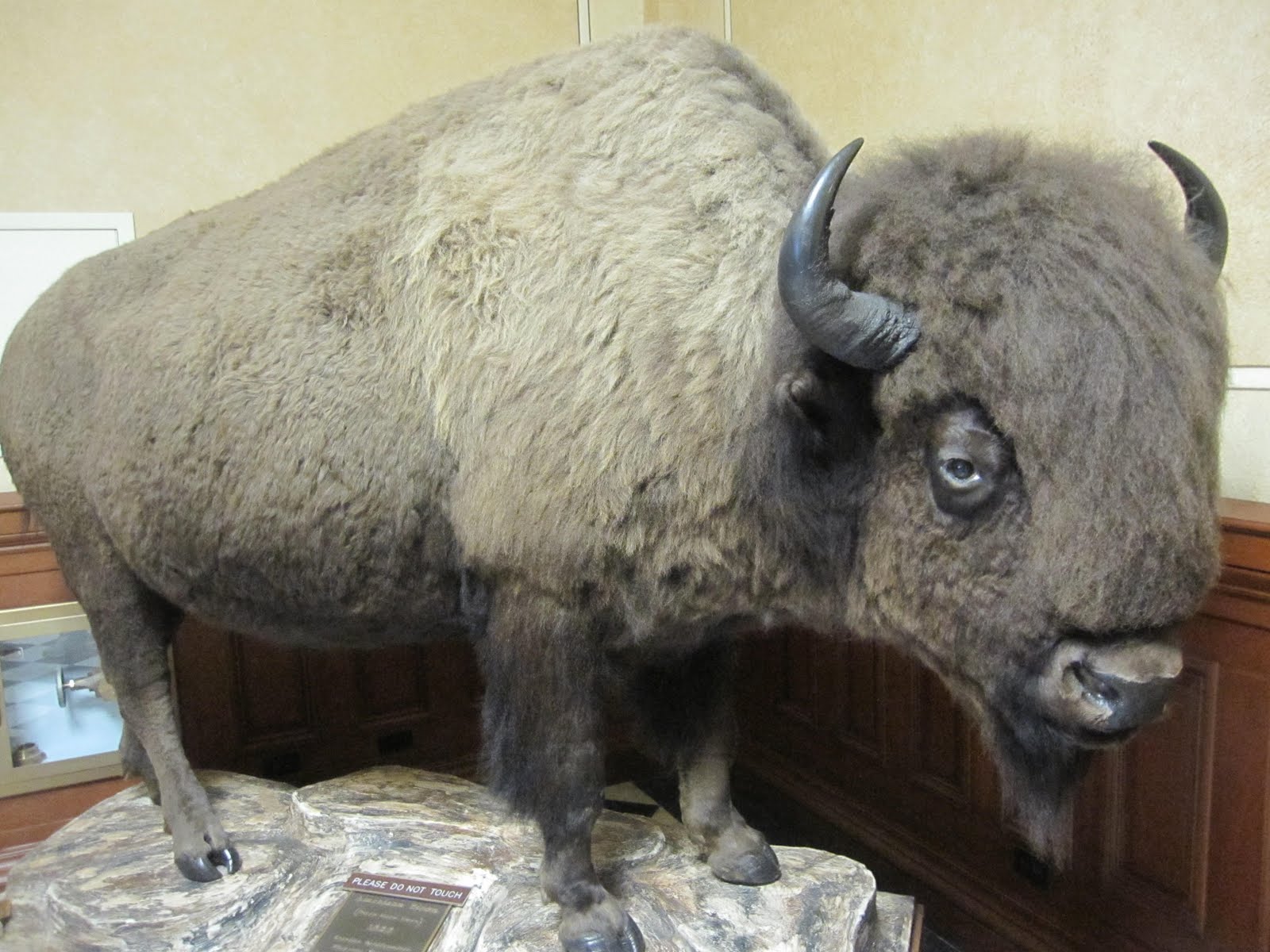
Big Bison.
The Senate chamber is the west wing of the second floor building; the House chamber is in the east wing of the second floor. Each chamber contains four impressively large murals by Allen True, who painted them in August 1917 for a cost of $500 each. The murals depict various aspects of the culture, history, and industry of Wyoming. The ceilings of both chambers are inlaid with Tiffany-style stained glass, with the Wyoming State Seal displayed in the center. 
Wyoming State Senate.

The brochure suggested a visit to Legislative Conference Room 302 is a must. Given that the Legislature was not in session I was free to essentially wander about the building. The reason this room is recommended is that a 1,000-lb, Tiffany chandelier, originally located elsewhere in the capitol, hangs beneath a beautiful four-pane stained glass ceiling.

Now late afternoon I had a session of Interstate driving as there really wasn't any alternative routes. I picked up I 25 crossed out of Wyoming and into Colorado skirting Denver's rush hour traffic. As I climbed on west through the foothills of the Rocky Mountains following Interstate 70 I reflected on the journey so far – dominated by the Great Plains. This broad expanse of prairie, farmland, and butte dominated grassland lying west of the Mississippi River and east of the Rocky Mountains plays such a pivotal role in US history. Be it pre-historic such as the fossils I saw at the Agate Beds, incredible eroded landscapes at the Badlands, or the complicated and at times tragic history of conflict between Native Americans and America's desire for westward expansion. That history continues through to the Cold War and the ongoing stationing of the most powerful and destructive weapons ever devised deep within the remote areas of the plains. The distances are vast, the settlements spare, and perhaps lacking in major tourist attractions but I love the Great Plains. To me they represent one of iconic landscapes of America.
I now entered another famous American landscape – the Rocky Mountains. Indeed, mountains would dominate the next chapter of my journey but for now I had only a little further to drive as my destination for the night was wonderful little town called Idaho Springs.

In early January of 1859, George Andrew Jackson, left his winter camp at the site of present-day Golden, Colorado to go on a hunting trip. While camped out on a sandbar where Chicago Creek flows into Clear Creek, Jackson decided to pan some of the thawed gravel around his campfire. Using his drinking cup, he washed out gold nuggets . It was the first substantial gold discovery in Colorado. Jackson, a Missouri native with experience in the California gold fields, was drawn to the area by clouds of steam rising from some nearby hot springs. Jackson kept his find secret for several months, but after he paid for some supplies with gold dust, others rushed to Jackson's diggings. The location was originally known as "Jackson's Diggings" but once the location became a permanent settlement, it was variously called "Idahoe" "Idaho City," and finally "Idaho Springs." The name Idaho being a based on the word Edauhoe meaning 'gem of the mountains' in the language of the native Arapahoe tribe.

Just like George Jackson it was the hot springs that drew me here. A number of years ago when skiing at the nearby Winter Park resort I came for a soak in the pools. I loved the experience and decided to stay the night at the hotel as it included admission to the pools in the price. They have a large indoor pool as well as these incredible cave baths.

Complete with flowering plants among live banana and palm trees the swimming pool is continually fed with hot mineral water at 115 degrees. With an overall temperature of 90 degrees.

Two tunnels were carved into the solid rock mountain side, between 1903 and 1911, specifically for the purpose of creating this unique "One of a Kind" facility. One cave for men and another for women, each with several huge, sunken, walk-in hot tubs filled with naturally hot mineral water at temperatures from 104 to 112 degrees. I had the tunnel to myself for a really wonderful experience deep within a mountain enjoying the warm water. Needless to say I sleep very well after a long day of driving, seeing more incredible sights and a long hot soak in the thermal waters.
No comments:
Post a Comment